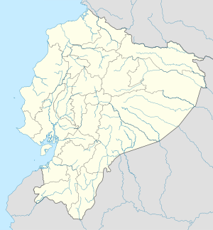
Quito
Quito (pronunciation in Portuguese: [ˈ kitu]; pronouncement in Castilian: [ˈ kito]), originally San Francisco de Quito, is the capital and second most populous city of Ecuador, located in north-west South America. From 2008, it also became the capital of Unasul. It is located north of Ecuador in the Guayllabamba river basin at the eastern slopes of the Pichincha (4 794 meters), a volcano ative in the Andes mountain range. Independence Square is 2,850 meters above sea level. Quito is the second highest capital city in the world after La Paz, Bolivia. The population of Quito, according to the most recent census (2010), is 2 239 191 inhabitants. The Quito area is approximately 422,802 hectares.
| Quito San Francisco de Quito ・ San Francisco de Quito | |||||
| |||||
| Surname: "God's face, Half the world, Light of America" | |||||
| Theme: "Very noble and very loyal city of San Francisco de Quito" | |||||
 Quito Quito Location ( | |||||
| Coordinates | |||||
|---|---|---|---|---|---|
| Country | |||||
| Province | Pichincha | ||||
| Spanish Foundation | 6 December 1534 (485 years) | ||||
| Mayor | Jorge Yunda | ||||
| Area | |||||
| Total | 372.4 km² | ||||
| Altitude | 2850 m | ||||
| Population | |||||
| City (2020) | 2011388 | ||||
| Metro | 3000000 | ||||
| Time zone | ECT (UTC-5) | ||||
| Website: http://www.quito.gob.ec/ | |||||
Quito is located approximately 35 km south of the Equator line. A monument marks the place as la mitad del mundo ("the middle of the world"). Due to the city's altitude and location, the climate in Quito is reasonably constant, with a maximum temperature typically around 21 °C on any day of the year. There are only two seasons in Quito, the summer (the dry season) and the winter (the rainy season).
Quito was founded on December 6, 1534 by Spanish Sebastián de Benalcázar, named San Francisco de Quito.
Etimology
According to the Ecuadorian researcher Jacinto Jijón y Caamaño (1890-1950), the word Quito corresponds "to the language of the colored people, on their basis here, which is particular to this language", that is to say, to the Tsafiqui language (of the ethnic Tsáchila). In the same explanation it appears: "Quito, the name of this capital, has given rise to several explanations: Quito, Quechua means dove: Quito, province, site, comarch, space, width, hole"
In the Vocabulary of the General Language of all Peru, written in 1608 by the Spanish religious man Diego González de Holguín, the names quito and quiti appear, in the sense of dove, place or province.
Other authors think that the name is a reference to the "Quitus" or "descendants of Quitumbe", which have populated the current urban area of Quito since the sixteenth century BC.
In 2006, the researcher Cristóbal Cobo created a multidisciplinary project with the idea of recovering the archeological sites of Quito. The name of the project became Quitsato, of tsáfiqui origin and, according to the new research, it means "the place of the middle" and it would have been the origin of the name.
Within the work carried out is the recovery of the Catequilla hill (2660 m), located in the region of the Pomasqui valley. On the top of the hill two stone circles were found that were probably used for astronomical and ritual observations related to the sun and the moon. The place is crossed by the Equator line and is a demonstration of the wisdom of the ancient pre-Inca inhabitants.
History
Pre-ceramic period (14000 to 2000 BC)
First settlers of the equatorial Andes
If one thinks that around the 14000s and 13000BC, the environmental conditions resulting from the glacier process and the abundance of the mountainous woods in the Andean valleys opened the way for the penetration and stability of some groups. Most of the material found corresponds to instruments for hunting or cutting parts. One of the main and oldest discoveries that confirm the existence of these hunting circuits is the archeological site of El Inga, at the feet of Mount Ilaló and the eastern mountain range.
The hunters and gatherers were people who lived collectively, moved according to their needs. They were organized, probably by "bands"; made up of men and women of all ages, where the strongest or wiser (man or woman) was his guide both in survival and in the spiritual part. The spirit of the coexistence group that originated in this time continued with predominance until arriving at what we currently call the collectivity (community) of various indigenous nationalities. The respectful and religious knowledge and exploitation of nature has made them cyclically roam in their territories, according to the presence of hunting animals or the times of fruit. The long time that this period lasted, is a demonstration that humanity was knowing the behavior of each element of nature and its validity for human survival. This is known as transhumance, which means that they weren't simple nomads as we thought they were, but they already knew the cycles. Transumance is a common practice in many people in the world today and is defined as a type of pasture in constant movement, adaptable in space and to zones of changing productivity. It differentiates itself from nomadism in having fixed stationary settlements and a main fixed nucleus (populated) from which the population that practices it proves. El Inga seems to have been a base camp of these first Andean settlers.
Climate conditions have not allowed the preservation of bone remains, whether from the first settlers of El Inga, or from the animals that hunted. Nor have they found traces of their food or of their housing. The only material you have to interpret this cultural complex is a series of fine stone utensils plowed by its inhabitants. The most common found materials have been basalt and obsidian. According to the 1965 reports by the US archeologist Robert Bell, it has been established that stone instruments exist in this area, such as: drawbar or projectile tips, cutters, facial knives, scrapers, drill tips. In total, they have determined around 50 different kinds of obsidian and basalt objects. Drawbar ends in a form called "fish tail" the style of those findings in Clóvis, in the United States are some characteristic pieces.
Training period (2000-500 BC)
The origin of agriculture and ceramics
According to the archeological research, the origin of agriculture and of the oldest ceramics in the Americas is on the coast of Ecuador around the year 3900 BC. with the Valdivia culture and the Atlantic coast of Colombia in Puerto Hormiga. Almost a thousand years later, the process of domestication of plants, sedentarization and the appearance of new technologies in the Andean region began.
Archeologist Robert Bell wrote about a ceramic piece found in El Inga, dated by C-14 in 1950 BC. "It seems that in the region of Ilaló there was continuity in human occupation from the paleoindian to the formative."
However, it is in the northern part of the city of Cotocolao where the oldest human traces of the training period were found. This population settlement develops from the year 2000 BC. and advances up to 500 BC; this gives a continuous permanence of more than ten centuries sustained, mainly by agriculture (corn).
In this place — located next to an ancient lake that is now dry — a large village was discovered, growing up to occupy an area of 26 hectares and reaching a population of approximately 750 inhabitants. It was composed of several districts or areas of grouped housing, which were separated by unbuilt intermediate zones, generally corresponding to the beds of voorocas or ravines.
The dwellings were rectangular and were five to eight meters long. Its walls were made of large lampposts covered with a technique similar to stick to plague and straw ceilings. They were built on artificial steps, a height of about 60 cm. In its interior, along the walls, it had wooden platforms for sleeping. Underneath the ground were digging storage wells and their center was occupied by a large cook stove and warm up. Outside the house, near the walls there were other stoves and storage wells.
Besides the houses, there were also small cemeteries in which more than two hundred skeletons were found in a perfect state of conservation, thanks in part to the fall of accumulated volcanic ash.
Archeological research revealed two types of burial: the oldest were tombs excavated in cangahua (consolidated volcanic ash), where the body of the deceased was placed lying on the side, with its legs folded against the body with a simple swarm made up of stones. Later on, these settlers practiced primary burials (flexed bodies, seated and some with evidence of being tied up to maintain the form) and secondary burials (bones regrouped by second inhumation, the longest placed in a basket or bracket for the skulls).
The varied ceramics allow archeologists to reconstruct the history of this civilization. The techniques used relate to the final phase of the Valdivia coastal culture, as well as to the Machalilla and Chorrera cultures. Due to the geographical location of Quito between the Pacific lowlands and the Amazon basin, the region has become an important and very active trade axis since ancient times. Exotic raw materials such as marine shells or cotton have come from very distant regions.
The inhabitants of Cotocolao were specialists in the work with stones as varied as quartz, serpentina, basalto and sillex that even exported to the coast besides the volcanic glass of obsidiana. There was a very strong network of product exchange between the Andes and the coast.
This civilization was destroyed by an eruption of the Pululahua volcano. This event was not produced suddenly, but in a way that gave the population time to leave the village. The proaverage of the archeological dates for the final occupation oscillates between 500 BC, while the geological date of the Pululahua ash is dated around 350 BC.
Regional Development Period (500 BC) - 1000 BC)
Jardín del Este, La Florida and Rumipamba
Between 1919 and 1933, the German archeologist Max Uhle came to Ecuador, invited by archeologist Jacinto Jijón y Caamaño. During this time he carried out excavations in the Cumbayá valley, located to the east of the current city. Here he found several burials that gave him the idea of the existence of a civilization characterized by technological advances with ceramics. The geographical location of these people is to be found in the current rural villages of Tumbaco, Puembo, Pifo and Yaruqui to the east, and has spread north through Cayambe to Caranqui (now IBarra) and south east through Chillogallo to Santo Domingo de los Tsáchilas.
Between 1986 and 1987, new excavations carried out in the Jardín del Este condominium, only 700 meters further away from the place studied by Uhle, confirmed the presence of an important pre-Columbian culture, which would correspond to that described by the Jesuit, Juan de Velasco, in the eighteenth century as "Quitu".
The current city of Quito is in the narrowest part of a plateau and in the Pichincha mountain's forks. It borders the east with several hills like Puengasí, Guanguiltagua and Itchimbía that are scattered over ravines the product of the system of faults in the Andes mountain range. To the south it extends to the area of Tambillo and to the north to Pomasqui-San Antonio. Its terrain is irregular with altitudes ranging from 2,850 to 3,100 meters.
Within the city, there are lake areas that form small swamps and that had great importance in the pre-hispanic era for obtaining tootor, hematites, fish and birds and even for agriculture in camellones, as has been shown in various research studies.
In the urban area of la Y, the former airport and the district of Jipijapa, the soils are made up of clay, lime and sand with pomes corresponding to lake and volcanic deposits, the same as the origin of the extinct lagoon of Iñaquito (old airport).
The geology of the plateau conditioned the pre-Hispanic settlements on the banks of the Pichincha volcano and its agricultural use. Their inhabitants occupied the flooded plains by developing an agricultural technology of camellones, like those located near the housing estates of Chillogallo and Iñaquito in the urban area of the city.
The current district of La Florida, located on the slopes of the volcano between 2,900 and 3,000 meters in height, between the ravines of La Pulida and San Juan, was discovered in 1983 in a necropole that archeologists from Ecuador and foreigners were interested in. Archeological research in the area has shown that La Florida has been occupied from the period of Training (2000 BC) to Integration (1500 AD). It is a complex settlement with housing sites, growing areas and necropolis. Their inhabitants developed a very advanced technology and sold both with the different villages of the Quito Plateau, and with the Serra, Amazonia and the coast. Possibly they had commercial ties with the inhabitants of the northwest region on the slopes of the mountain range. In 1999, on Mariscal Sucre Avenue, known as the Western highway, located to the north of the city, other important traces of the former settlers of the Quintin Plateau were found. On a 35-hectare plot of land, the Salvation Fund led by archeologist Holguer Jara recovered an archeological site, thanks to the work of the city hall and the Central Bank of Ecuador. In this place, human remains have been found since the period of Training (1500 BC), Regional Development (500 BC) and mainly Integration (1000 AD.).
All these remains found in the excavations of Jardim del Este, La Florida and Rumipamba would correspond to the civilization called Quitu.
Integration Period (1000 BC)
It is called a period of integration at the end of the pre-Inca era during the pre-Columbian Ecuadorian history. It is a time interval, approximately from 1000 to 1500 BC, when some groups begin to identify themselves not only by the cultural unit predominant according to the area, but also by the increasingly vigorous processes of political unification, with varied forms of more or less clearly structured state organization.
During this period, the commercial networks that have been established since previous periods have led to the enrichment of the masters of the coast and to greater architectural complexity of the settlements with large structures and ramps. It has been a long period of great cultural development for most groups, during which particularly significant events have changed the course of history: the Inca occupation and the Spanish conquest at the end of the 15th century and the beginning of the 16th century.
Among the human groups of this historical period, they stand out in the Andean valleys beginning in the south of the current Ecuador: Paltas, Cañaris, Chimbos, Puruháes, Panzaleos, Quitus and Pastos on the border with the current Colombia. In the river basins of the coast we have large confederations of merchants and navigators, like the Manteño-Huancavilca and the Atacames and in the Amazon the Omaguas, Quijos and Canelos. All civilizations have formed networks to exchange highly ative products, the tracks of which are still preserved in various regions.
The site called "Quitu" became the communications axis between the Amazon rainforest, the northern Andes, the cloudy forest of the western hillsides of the mountain until it reached the Pacific Coastal plain.
The archeological sites of Rumipamba and La Florida have been the most studied by archeologists because they are the places that have the best preserved traces.
In the necropolis of La Florida, they found graves with a dating of 620 d.C. up to 1505 d.C. The tombs consist of very deep wells that can reach a depth of up to 15 meters, with a constructive system very similar to tombs found in other civilizations of the northern Ecuadorian Andean and in the south of Colombia, mainly of the civilization of the Pastos, also known as Carchi (600 AD), and which were reported by archeologists and historians like Jacinto Jijón y Caamañino Carlos Emilio Grijalva and Carlos Manuel Larrea.
The burial was accompanied by funeral migraines that include, besides the Spóndylus shell, shell, bone, ceramic and some metallic objects. These findings, dating from 100 (?) to 700 d.C., probably represent a formative phase of the metallurgy of the north of Ecuador (Pasto-Carchi) and the south of Colombia (Nariño).
The technique used in metal parts was hammered over gold and copper alloys, called tumbaga or gold almost in pure form: foundry is scarce. Some of the most representative pieces are necklaces, earrings, narigueiras, rings and a scepter.
When León Doyon in 1989 carried out the excavations of the deep well and central chamber graves in La Florida, he came to the conclusion that they were burial of characters from the Chitera elite who in their rituals sacrificed to a number of people to accompany them on the trip beyond. Until this moment, none of the researchers who had excavated this kind of grave in the Northern Andes had proposed this kind of rituals.
Other tombs then excavated constitute multiple burials that relate to a symbolic thought represented both in the migraines and in the construction of the tombs. People wouldn't have been buried simultaneously, but according to them they were dying, and on tombs two and four migraines are individual.
The Inca conquest (ca. 1490 - 1534)
Expansion of the empire
The Inca constitute a great civilization that has dominated a wide range of lands across South American territory. According to a mythical report, the Inca people initially settled in the Cuzco region and had as their first great leader Manco Capac and his wife Mama Ocllo. All this happened in the year 1200 after Christ. Because of the more favorable geographical conditions, the Inca presence concentrated primarily on the central region of the Andes.
Around the year 1300, the Inca established a process of territorial expansion that sought the highlands between the Andean mountains and the plains on the Pacific coast. Under the tutelage of Emperor Pachacuti, the territorial expansion of the empire began. The Inca came to dominate the territories of Peru, Bolivia, the north of Chile and Argentina.
In the year 1460, the expansion began to the northern Andean, reaching the present Ecuador and the south of Colombia. The administrative capital of the empire was Cuzco in Peru, but the Inca Túpac Yupanqui founded the city of Tumipamba in the ancient village of the cañari culture of Guapondélig. This Inca married an indigenous princess and had a son named Huayna Cápac, who continued the northern conquest until he arrived in the current town of Pasto in southern Colombian.
The current Ecuador was the province of Chinchaysuiu, which means "the land of the jaguar." The conquest of what is now Ecuadorian territory should be motivated, to a large extent, by the high agricultural productivity of the Andean valleys, above all in corn and potatoes. It may also be the fact that it has types of crops specialized in the northern Andes, such as the coca, the sacred plant that was cultivated in a special manner in the Pimampiro region (now the province of Imbabura). Furthermore, as the populations of the north of the current Equator knew better than anyone how to cultivate this plant, entire groups of inhabitants from this zone were transferred to valleys of a similar climate in other regions in order to improve and expand its cultivation.
Another reason for the conquest of the Andean North may be related to the fact that the Ecuadorian coast was America's main place for obtaining the "mullu" or Spondylus shell, an object of great value to the Andean peoples, both for its religious meaning (worship of fertility and offering to the gods) and for its great value as a raw material for making jewelry and decorations.
The Inca conquest of this region was initiated in the 15th century by Túpac Inca Yupanqui, son of Pachacútec, founder of the Inca empire. His son, Huayna Cápac, was the first sovereign born in the current Ecuadorian territory and established his residence in Tomebamba, baptized by the Spaniards as the city of Cuenca. He conquered the territory of the Quitus by the brutal wars waged in the territories of the indigenous Caranquis (currently in the provinces of Pichincha and Imbabura) and his final victory would have been achieved after the massacre in the lagoon of Yaguarcocha (the ‘blood lagoon’ in Quechua) in 1532.
Cologne
Spanish conquest and colonization: 1526-1534
Even though the first contacts of the Spaniards with Ecuadorian territory began in 1526, the real conquering company in 1534 broke down as conqueror Sebastián de Benalcázar. The conqueror, without the consent of his superiors, began Quito's conquest from the city of San Miguel, to the north of Peru. When he received news that the conqueror Pedro de Alvarado, the Governor of Guatemala was approaching a large fleet on the coast of those lands, where, according to tradition, the treasures of Atahualpa, Benalcázar and an army of almost two hundred men and about eighty horses took a trip north.
The indigenous resistance to the Spanish invasion led by General Ina Rumiñahui continued during 1534, with Diego de Almagro founder of Santiago de Quito (in the current days of Colta, near Riobamba), on August 15 of the same year. On August 28, the city was renamed the San Francisco de Quito. The city later moved to its current location and was refounded on December 6, 1534 by 204 settlers led by Sebastián de Benalcázar, who captured Rumiñahui and effectively ended any organized resistance.
Rumiñahui was then executed on January 10, 1535. In Talavera, Emperor Carlos V signed the declaration by Cédula Real on 14 March 1541, as a city, and on 14 February 1556 the title Muy Noble y Muy Leal Ciudad de San Francisco de Quito was given ( "Very Nobre and Leal City of San Francisco de Quito"), as well as giving him the flag and arms coat that is used to this day.
The conquest of the Amazon: 1541-1542
Gonzalo Pizarro is appointed Governor of Quito and in 1541 organized an expedition to eastern lands. It led to countless indigenous people who died along the way. They decided to follow the route previously explored by Gonzalo Díaz de Pineda. In the expedition, Francisco de Orellana joined. Faced with a lack of privations and food, Orellana is sent to continue down a river in a bergantim, which ends up arriving in the Amazon River on February 12, 1542. Pizarro, without news, decided to return to Quito with only 80 men of the total who accompanied the expedition. Orellana continued his journey to the Atlantic and finally to Spain to inform the king about this new discovery that would be one of the most important in America's colonial history.
Power struggles among conquerors: 1537-1548
The struggles to control the new conquered territories produced the battles of Salinas and Chupas between those who supported Diego de Almagro and Francisco Pizarro, known as "Almagrists" and "pizarre players." The Crown intervened by sending representatives to pacify the region and establish its control. The promulgation of the New Laws of King Carlos I in 1542 and completed the following year, made the climate of war continue among the conquerors. The best known representatives of these laws were the Dominican priests Francisco de Vitoria and Bartolomé de las Casas. Within those reforms was the protection of the Indians and the prohibition for the religious and the Spanish to have orders (a system of slavery and exploitation against the Indians).
The person in charge of the execution of the New Laws in this part of the continent was Blasco Núñez de Vela, the first Vice-King of Peru, who took over the government after the Vaca de Castro on May 17, 1544. On January 18, 1546, a battle was fought known as the Battle of Quito or the Battle of Iñaquito, because it was fought in the location that is now being established by the La Alameda and El Ejido parks. Núñez de Vela died tragically beheaded, although Benalcázar was forgiven.
The Crown's response to similar bloody events was to try a negotiation with the newly arrived settlers who had the ambition to obtain privileges and were faced with the contractors. The authorities decided not to apply the controversial laws, giving the settlers some control over American affairs, in exchange for consolidating unity.
In order to face up to Pizarro, the religious Pedro de la Gasca was appointed to do so. The cleric obtained the support of the settlers and managed to lift an important military force. Governor Pedro Puelles, placed in Quito by Pizarro was assassinated and the two armies ended up facing themselves in Jaquijaguana, near Cusco at the beginning of 1548. Pizarro was defeated and executed with his lieutenants. Finally, the Crown has consolidated its power even with certain concessions to local government.
From the creation of the Royal Quito Audience to the Alcabalas Rebellion: 1563-1593
After the military conquest and to secure dominance, the Spanish state has deployed its new administration through three important institutions: adequate capture, bevy and hearing due to the circumstances in the environment in which they were deployed. The cabildo took charge of the sharing of land and the protection of the Indians, besides becoming the custodial of the economic interests of a new urban elite.
The creation of the bishop of Quito in 1551 was the most important institution because it was the link between the state and the church.
On August 29, 1563, King Felipe II created the Royal Audience of Quito, which was an administrative district dependent on the vice-reign of Peru with the capital in Lima. The establishment of this hearing has consolidated the recognition of the particular unity which, in both geographical and historical terms, formed the territories designated for this administrative division, whose main function was to be a superior court of justice, with additional functions in the legislative, executive, economic and military terms, with enormous effective autonomy.
The chief authority of the Royal Audience of Quito was the President who was a Spaniard named by the Crown.
In addition to the Spanish founding cities, there have been several conserved indigenous villages. The new colonial legislation established a division between the Republic of White and the Republic of Indians. One of the first forms of Spanish colonial government was known as the indirect mandate, which consisted of keeping the indigenous authorities with the objetive of collecting taxes.
During the government of the viceroy Francisco de Toledo in Peru (1569-1581), several fundamental administrative and fiscal reforms were carried out that consolidated colonial power in all the vice-reign and in the Audiencia de Quito.
At the end of the sixteenth century in Quito, there was a conflict between the president of the Audiencia Manuel Barros de San Millán, with inclinations in favor of the Indians, and the Cabildo, an institution that defended the interests of the whites. Between 1592 and 1593, the Alcabalas Revolt was held up against the imposition of a tax that affected local trade. After all, the Crown has once again triumphed, but a certain balance of strength has been maintained between it and the local authorities.
Colonial consolidation, earthquakes and volcanoes: 1600-1700
Between the last decade of the sixteenth century and the first of the eighteenth century, there was relative economic and social stability. At the same time as the Spanish colonial bureaucracy was being strengthened, a new ethnic diversity was being deepened.
The seventeenth century began with the administration of President Miguel IBarra, who founded the city that had his name in 1606. During this period, the construction of churches and convents such as the Church of the Company, El Sagrario, Guáops and San Diego continued. Religious missions have spread throughout the eastern region, while the production of the Guayaquil shipyards has been regularized.
Around the 1560s, the Royal Audience of Quito began to show itself to be a strategic region within the Hispano-American commercial system as a producer of tissues coming from the obrajes installed by the Spaniards, mainly in the North-Central Serra (current provinces of Chimborazo, Tungurahua, Cotopaxi, Pichincha and Imbabura). In these lands, the indigenous peoples were known since ancient times for their textile ability, which was used by the Iberian people.
At the same time, the conquerors discovered Zaruma's gold mines, regarded by many chronologists as the richest land until arriving at Potosi. The Crown authorized its exploitation, the peak of which developed between 1585 and 1628. Mining has become the first driving force in the colonial economy until the discovery of the silver mines in Potosi hill in Bolivia and the mines have been blown.
Audiencia's wealth, due to a lack of mines, concentrated on textile production. The main markets were the cities of Lima and Potosi. By the year 1600, Quito had consolidated himself as the most important textile center in South America. The difficulty of bringing fabrics from Spain, the abundant cheap indigenous workforce, with a great mastery of the most varied techniques, and the need to have people working with the objetive of collecting taxes for the king, were some determinants for the success of textile production. Often, the works were farm sites with inhuman working conditions.
During the presidency of Antonio de Morga (1615-1636), textile production reached its maximum. In 1622, the University of São Gregório Magno was founded by the Jesuits, who existed together with the University of Santo Tomás, which was one of the Dominicans. The civilian and church power and the struggles between Spaniards and Creole for controlling religious orders were the emphasis that marked this period.
Between 1630 and 1650, there were economic difficulties, while the Spanish produced a monopoly on land. Volcanic eruptions, pests and pirate attacks in the port of Guayaquil hit the Royal Audience. Around 1678, Lope Antonio de Munive was appointed President and at the time, in order to avoid the spread of the plague, the king ordered the creation of new obrajets to be closed.
In 1660, there was a strong eruption of the Guagua Pichincha volcano, which produces ash and pyroclastic flows and generation of secondary lakes in various sectors of the volcano.
The last decade of the 17th century was hit by a severe drought, as well as an earthquake that destroyed the city of Tacunga (now Latacunga) in 1692, and which hit again in 1698, causing many losses and damage to Tacunga, Ambato and Riobamba. The economic crisis that began at the end of this century continued into the following. However, the production and commercial activities were still large. In 1681 there were 200 jobs with almost 30 000 workers.
From the Geodetic Mission to Illustration: 1736-1808.
The 18th century was the scene of profound and not always positive changes in the province of Quito. The death of King Carlos II of Spain, known as the "The Spelled", caused political chaos and his succession triggered a war on the Iberian Peninsula between several European nations that ended with the Habsburg dynasty and marked the entry of the Bourbon dynasty. Even though the war did not hit the ultra-amd colonies directly, the establishment of the Bourbon house on the Spanish throne has led to various social, economic and political changes.
Borbonic Reforms have included more controls on the colony trade and pressure to buy products made in Spain. On 27 May 1717 the Vice-Kingdom of New Granada was established with its capital in Santa Fé de Bogotá. Quito became dependent on him, but it was years of instability, because with the suppression of what vice-reign in 1723, Quito once again depended on Peru until 1739 when the Vice-Kingdom was restored. The economic situation has worsened in this century. The relative autonomy achieved in the 17th century collapsed.
Quito lost his markets to sell his textiles and poverty increased, while several new institutions were created as the public farm while the Crown gave the concession of nobility bonds.
The situation was complicated by the increase in tensions between civil and church power. The Catholic Church had control of most lands, besides the culture of people.
Between 1728 and 1736 he governed the Royal Audience, President Dionisio Alprecoy y Herrera, an official representing the House of Bourbon, who tried to carry out various reforms to reform the public administration and to control the private power and the Church, in particular the anarchy within the clergy.
It was almost at the end of his administration that the French Geodetic Mission arrived in Quito, organized by the Royal Academy of Sciences of Paris and King Luis XV of France. The main objetive was to measure an arc of the terrestrial meridian. However, in addition to science, the mission had an influence on the dissemination of new ideas illustrated by the Quitewine elite. Within the mission, he highlighted the British geographer born in Riobamba Pedro Vicente Maldonado.
Between 1745 and 1753, he governed Félix Sánchez de Orellana III Marqués de Solanda, the only fifteenth who was the president of the Royal Audience and who made some reforms to the Royal Palace. During his presidency, there were clashes between hats and creole that he could not control. Between 1753 and 1761 he governed Juan Pío Montúfar y Frasso, I Marquis de Selva Alegre. During the administration of Manuel Rubio de Arévalo (1761-1767), the State consolidated the centralization of political power. The worst measure was the establishment of the "standstill" or monopoly on spirits in 1764. At the same time, a new customs tax was imposed that rationalized the collection of the Alkabala, which was the sales tax that collected the Crown. This adversely affected the producers of spirits and traders. In 1765, the people rebelled the standoffs that sparked a series of uprisings in the popular and indigenous sectors that were cruelly repressed by the authorities.
José Diguja was president from 1767 to 1788 and during his period he applied an interventionist policy, typical of the reign of Carlos III. It was this president who had to execute the order to expel the Jesuits in 1767.
Reforms added the struggle for political and economic power until the end of the 18th century.
In the middle of this, the Spanish Crown was constantly threatened by the danger that its overseas territories would be invaded by the English and French. In order to avoid this, it was decided to explore those remote lands and to achieve the dual purpose of claiming their possession and, at the same time, to draw up an inventory of the natural resources that could be useful in industry, medicine and trade. To this end, three major expeditions have been organized: Peru (1777-1788), New Granada (1783-1815), and New Spain (1787-1803).
In 1985, Ecuadorian physician and researcher Dr. Eduardo Estrella discovered in the archives of the Royal Botanical Garden of Madrid all the information of the botanical expedition developed by botanist Juan José Tafalla Navascués between 1799 and 1808 and which was known as Flora Huayaquilensis.
Nevertheless, in spite of the problems, this period known as illustration saw the flowering of the arts and sciences in Quito with important personages such as physician and journalist Eugenio Espejo (1747-1795), one of the pioneers of Latin American literature and libertarian ideas; Jesuit Juan de Velasco, author of the History of the Kingdom of Quito, considered the first monumental work on the history and identity of the current Ecuador. In the arts plan, the Quitere School reached its climax with great artists like the indigenous Manuel Chili Caspicara and the half-breed Bernardo de Legarda.
Independence and Great Colombia
The Quito Revolution (1808-1812)
The Napoleonic invasion of the Iberian Peninsula has turned the peninsular authorities into usurpers of power. The nobility crioula americana resolved the creation of government joints, with the purpose of demanding a return to the legitimate monarch. On December 25, 1808, a group of creoulos aristocrats from Quito met at a Christmas dinner at the Chillo Companhia farm, owned by Juan Pío Montúfar y Larrea, II Marquis de Selva Alegre. A few months later, on August 9, 1809, at the house of chittiff Manuela Cañizares, they held another meeting. Among the most important personages were Juan de Dios Morales, Antonio Ante and Manuel de Quiroga, as well as the Marquis who was elected president of that junta.
The accomplished people did not know the authority of Count Ruiz de Castilla, the president of the Audience, and on August 17, 1809 they signed an attempt at independence.
The life of that junta was precarious. The expected support from Cuenca, Guayaquil and Pasto could not be achieved. The Spanish authorities have monitored the situation. Unfortunately, the Kyrgyz militia did not have a good level of organization. The viceroy of Lima sent a military force that surrounded Quito, while the deputy king of New Grenada sent troops north and finally the junta had to dissolve. Count Ruiz de Castilla returned to government, offering pardon to the rebels, but in truth imprisoned more than one hundred revolutionaries in the prisons of the Royal Quartel that was installed in the building of the former university of the Jesuits.
The people of Quito reacted on August 2, 1810 and went to the streets trying to take the barracks by robbery. This is how the Spanish troops also reacted and a cruel massacre was launched in which more than 300 people died.
In 1812, the son of the Marquis of Selva Alegre, Carlos Montúfar arrived as the Commission of the Spanish Council of Regency, but his arrival, far from calming the mood, motivated the creation of a new government junta in which Montúfar had a lot of influence.
The articles of the solemn partnership and union pact between the provinces that form the State of Quito are hereby established. In that letter, Fernando VII was recognized as the only monarch. However, this joint also had to dissolve and the realists returned to control in 1812.
The Realistic Victory (1812-1820)
Between 1812 and 1820, several Spanish authorities governed the Royal Audience of Quito in the midst of tense calm and severe repression. The wars in Spain that ended the French invasion and the restitution of the Spanish monarchy led by Fernando VII were fundamental to the American liberation process.
The Final Release (1820-1822)
On October 9, 1820, a group of notable creole led by poet José Joaquín de Ollise gathered in Guayaquil and declared their independence, creating the Guayaquil Free Province, also known as the Guayaquil Republic. This important event motivated other movements within the audience, such as Cuenca's independence on November 3.
Soon after the declaration, one of the first actions that sought the new republic was the release of the rest of the hearing, but, after some victories, the subsequent losses forced the weak Guayaquilean army to retreat. In this complicated situation, General Simón Bolívar since Colombia sent his best general, the also Venezuelan Antonio José de Sucre, to command the operations.
After a loss against the realistic army, the libertarian troops managed to cross the Andes and on May 24, 1822, Antonio José de Sucre successfully led the Battle of Pichincha. His victory marked the independence of Quito and its surroundings.
Republic of Great Colombia (1822-1830)
Just a few days after the Battle of Pichincha, the city's leaders proclaimed their independence and allowed the city to be annexed to the Republic of Great Colombia.
On July 26, 1822, an interview was held between the liberators of South America, José de San Martín from Argentina and Simón Bolívar. The main objetive was to discuss the sovereignty of the province of Guayas, the freedom of Peru and the ideal form of government for the new republic.
In 1819, the new republic was formed, as part of the General Capitania of Venezuela and the Vice-Kingdom of New Granada, divided into three departments: Venezuela, Cundenmark and Quito. Bolívar is appointed President and according to Uti Possidetis Juris, the territory of the Audiencia de Quito belonged to New Granada. The current Ecuador was attached as the South Department.
Age Republican
Creation of the Republic of Ecuador (1830-1845)
On May 13, 1830, after the separation of the Department of the South of Great Colombia, the Republic of Ecuador was created in the first Riobamba Constituent Assembly, whose capital was the historic city of Quito. This constituent has chosen President of the Venezuelan General Juan José Flores who will dominate the national political scene for some fifteen years and has managed to be the meeting point of countless heterogeneous local and regional interests. The period is characterized by the internal state of war. The opposition is centered on the so-called ‘Quitenho Livre’ group and the personality of Vicente Rocafuerte.
A second constituent, celebrated in 1835 in the city of Ambato named Guayaquilenho Vicente Rocafuerte, President of Ecuador. With liberal ideas, he represented the economic interests of the coast, linked to international trade and in this logic, centralizing efforts are made. His government met with enlightened despotism.
The 1839 congress named General Flores again as President. He sought to perpetuate himself in power. The opposition of Rocafuerte, the Philanthropic Society, the nobles of Guayaquil and the clergy grew in its opposition.
Martist and Urvina Revolution (1845-1860)
In March 1845, a statement against Flores was produced in Guayaquil, the same one that called a provisional government an attempt by the coastal oligarchy to obtain power. Flores prefers to sign an agreement, but a new Constituent in Cuenca elects president to Vicente Ramón Roca, whose administration follows from the threat of invasion of Flores and economic difficulties. General José María Urvina appears in the middle of that political scenario, but in a new constituency in Quito he is appointed President Diego Noboa.
However, with the Martist Revolution, General Urvina became the most influential character in national politics and the most influential leader within the army. In 1851, he was appointed president and declared the abolition of slavery, as well as the abolition of taxes for the indigenous and an literacy campaign for the troops.
These progressive measures for the time provoked hatred of the landlords of Serra, even though they managed to get the support of important popular sectors.
This period was marked by a deep economic crisis, political instability that led to the separation of the state in three republics in Quito, Guayaquil, Quito and Loja, as well as neighboring conflicts with Peru.
Republic of the Holy Heart of Jesus (1860-1875)
In 1861, a new National Convention was brought together, chaired by Juan José Flores, the same one that made the seventh political letter and first appointed García Moreno, first President Interim, then Constitutional President.
García Moreno was the one who did the most work to transform the city. It was an energy representative who, at the same time, tried to carry out his project of introducing a regime based on the rules of public law in accordance with the Catholic concept of the State. It has fostered an accelerated pace of construction and infrastructure endowment, as well as the unity of the country through the concentration of power.
During his administration, various works such as the road between Quito and Riobamba, Simbambe and Guayaquil were built. The road began in São Domigos Square and continued through a bridge that was built as one of the first flyovers. Over the road, while downstairs the current La Ronda Street.
He had new trees placed in La Alameda Park and along with the German Jesuits Menten and Dressel built the Astronomical Observatory. Around the city center, on the banks of the volcano Pichincha constructed the "Panotic" (1868-1874), a solid structure intended for imprisonment, the name of which responds to a central circular body since it is possible to have a view of all five wings of the building. Architects Reed and Schmidt took the idea of the arrest of La Santé in Paris. Other important works included the National Polytechnic School and the Fine Arts School.
As part of his policies, his idea of progress included the Church as a fundamental stone. He sought to sign an agreement with the Holy See, brought the Jesuits back, declared Our Lady of Mercê as a national baker in 1861, and Ecuador was officially consecrated to the Holy Heart of Jesus in 1874.
On Thursday, June 3, 1875, Quito witnessed the city's first night lighting through electric power, in an experiment conducted in Broad Square by professors from the Polytechnic priests Eduardo Brugier and Joseph Kolberg.
He ruled with a hard hand from 1859 to 1865 and from 1869 to 1875, when he was murdered in Quito in the Government Palace.
Gabriel García Moreno
Optical.
Frontispice of the Government Palace ordered by García Moreno.
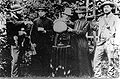
Founders of the National Polytechnic School.
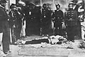
Murder of García Moreno on August 6, 1875.
Veintemilla, Restoration and Progression (1875-1895)
At the end of 1875, Antonio Borrero, a Catholic supporter of liberal principles, an austero man, came to power with incensorable democratic principles who, at a determined moment, presented resistance to the arbitrariness of García Moreno.
In an attempt to fight against the Constitution approved by García Moreno, Borrero failed. During the crisis, the Guayaquilean oligarchy supported General Ignacio de Veintemilla's candidacy, and in September 1876 a severe coup d'état ended up putting the new military in the palace. Seven years have managed to remain in the Veintemilla power, during which few important public works were carried out.
During his government, the Sucre National Theater was built under the direction of the German architect Schmidt, where the butchers used to work.
The persecution of the Church by General Veintemilla's dictatorship claimed 20 victims on March 1, 1877, when in the square of San Francisco the people who had appeared in defense of the French-speaking Spaniard Father Gago, who was accused of attacking the government in the sermon that morning, were shot.
On Good Friday, March 30, 1877, Quito José Ignacio and Czech Barba's bishop was killed by poisoning in Cathedral.
On November 14, 1877, the first attempt to strike against the regime of the dictator Ignacio de Veintemilla took place. On January 10, 1883, Quito was defended by troops led by Marieta de Veintemilla, the dictator's niece. On 9 July of the same year, the port of Guayaquil was taken over by an alliance of forces from all political parties. This situation ended with the overthrow of the dictatorship and the beginning of a national crusade, known as the Restoration. Liberals-Catholic and ultra-conservative continued the struggle for control of the State. With the victory of José María Placio Caamaño in 1884, the alternative of progressive thinking was taken into force. The works of his period highlight the creation of a Botanical Garden in the northern part of the La Alameda Park, with the leadership of the Italian Jesuit Luis Sodiro and the improvement of the northern road that united Quito with Pusuquí.

However, his greatest work was the union of Quito and Guayaquil by means of the telegraph, inaugurated on July 9, 1884.
Between 1888 and 1892 he governed Antonio Flores Jijón, the son of the first president of the Republic. Its main works for the city were the placement in the Government Palace of the iron bars that belonged to the former Tulheria Palace in Paris and the National Exhibition celebrated in La Alameda Park in 1892.
Between 1892 and 1895 he governed the liberal Catholic Luis Cordero. During his term of office, under the leadership of architect Schmidt, repairs were carried out on several public buildings, the source was constructed at the church of Santa Barbara and water distribution improved since Mount Atacazo.
Liberalism (1895-1912)
The increase in cocoa exports has changed the economic power concentrated on the owners of the land of Serra pata, the new coastal agro-exporters. This growing aristocracy made up of traders and bankers began to acquire hegemony.
In the middle of this new political scenario, the Liberal Revolution was unleashed, in which this new liberal-type elite, along with the coastal peasants known as the "mountains.''
General Eloy Alfaro took power after a long process of fighting and withdrawing, which has its culmination in the Revolution of July 5, 1895.
State reforms meant the permanent existence of a conservative conspiracy. The division within the liberals became visible in 1901 with the election of General Leonidas Plaza as successor. He continued with the most radical reforms and at the end of his period tried to prevent Alfaro from returning to the government, but the leader of liberalism managed to return with a coup d'état for a new administration between 1906 and 1911.
Liberalism meant the consolidation of a national state, which brought about many transformations in society. In the economic part, Ecuador entered the international market thanks to the peak of the production and export of cocoa. The 1906 Constitution approved the Civil Marriage Act and divorce, as well as guaranteeing freedom of worship.
It also meant taking away the economic power and the strong political influence that the Catholic church had, through various measures such as the Law of the Dead Hands that confiscated the properties that were concentrated in the clergy.
Among the most important works of this period for the capital city, they highlight:
- Creation on June 5, 1897 of the Mejía National Institute, the first secular college in Quito and the second in Ecuador.
- Creation on 14 February 1901 of the Manuela Cañizares College, the first female educational institution in Ecuador.
- Reopening on May 24, 1904, the School of Fine Arts, annexed to the National Music Conservatory and led by Pedro Traversari.
- Construction of the Exhibition Palace by the Portuguese architect Raúl Maria Pereira from 1907 to 1909.
- Construction of the monument to Independence in 1909, I congratulate João Batista Minguetthi, Adriatic Froli and Francesco Durini.
The most significant work of the period was the completion of the railroad that brought together the port of Guayaquil and Quito. The first train arrived at the Chimbacalle station on July 25, 1908.
After leaving power in 1911, and his absence from Central America, Eloy Alfaro decided to go back to try to calm a new radical revolt, yet the clashes between the two political bands ended the General's arrest. On January 28, 1912, the leaders of liberalism, including Eloy Alfaro, Flávio Alfaro, Medardo Alfaro and Ulpiano Páez, were cruelly dragged from the panotic in the streets of the center to El Ejido Park where their bodies were burned, in a dancing event known in history as "the barbaric campfire."
Plutocracy (1912-1924)
After the revolutionary phase, the 1912-1925 stage was the predominance of the liberal oligarchy. The second administration of Plaza, hit by Esmeraldas's campaign against the guerrilla of Colonel Carlos Concha, who consumes all the government's resources, did not manage to carry out many public works. However, the building of the Post Office Palace behind the presidency and the beginning of the north railroad to connect Quito with IBarra and later with the port of Esmeraldas were hired.
In 1914, the electric tram service was launched and on October 8 of that year a new type of public transport began to circulate, even if it belonged to a private company. The route started at the same train station in Chimbacalle, continued through the current Maldonado Street to São Domingos and ended up on the current Colón Avenue in the district of La Mariscal. There was another line that connected the Great Square to the San Diego cemetery.
For 1917, the telephone center was expanded in 1900, if it continued with the progress of the construction of the Post Office Palace and the construction of a modern sanatorium on the hillside of San Juan was carried out.
The city grows to the north and new residential settlements are being built in the districts of La Mariscal, América and La Floresta.
In 1920, he landed the first plane called El Telégrafo on the plain where the old airport was built.
The fall in international cocoa prices has led to a deep economic crisis. President José Luis Tamayo, representative of the Guayaquilire oligarchy, was in charge of presiding over the 100th anniversary of the Battle of Pichincha in 1922. In the place where the battle that liberated Quito from colonial power was fought, the president ordered the placement of an obelisk in honor of liberators Antonio José de Sucre and Simón Bolívar. As part of the celebrations, Mayo Avenue 24 opened over the ancient Jerusalem ravine while El Ejido was transformed into Mayo Park.
The Tamayo dictatorial government ruined a general strike by the workers of Guayaquil on 15 November 1922 that ended the killing of hundreds of people.
In 1924 Gonzalo Córdoba was appointed president at a time of deep crisis of liberalism.
The July 1925 Revolution
On July 9, 1925, a group of progressive military overturned the new president. Isidro Ayora took office in 1926 and was appointed constitutional president in 1928. Even if he did not make many material works, his policies have brought about important transformations that have consolidated the unitary state and the importance of Quito as the capital of the Republic. During its administration the Central Bank of Ecuador was created, the Superintendence of Banks, the Fiscal Audit of the State and the Pension Fund for Retirement. He inaugurated the Central Bank building, built by the Durini brothers, the Post Office Palace and inaugurated the Quito-IBarra road.
The Four Day War (1932)
At a time of weakness in the coastal elite, the Andean terrent rode to the conquest of power, winning the triumph of Nepali Bonifizer. His disqualification by a part of Congress provoked the four-day War, in which an important protagonist was the National Workers' Compression, a union of artisans led by the right. On August 27, the garrison of Quito was raised. The following day, several military units coming from the north and south of the country marched over the city. Meanwhile, Congress President Baquerizo Moreno has resigned and applied for asylum on a diplomatic mission. The clashes lasted four days. Finally, Bonifizer left the presidency and Alberto Guerrero Martínez was appointed as an interim.
Between Velasquismo and the bananeiro peak (1934-1964)
No doubt one of the most charismatic personages in the history of Ecuador was José María Velasco IBarra (1893-1979). His political leadership for more than 45 years and five presidencies made this period known as "Velasquism."
The first presidency of Velasco IBarra ended with a coup d'état in 1935. Federico Páez exercised for two years a civil dictatorship (1935-1937) with the support of the Armed Forces. However, it was overthrown by General Alberto Enríquez Gallo, who ruled the country between 1937 and 1938. In this short period the Labor Code was approved. Enríquez handed over power to a Constituent Assembly in 1938 that was dissolved by Aurelio Mosquera Narváez, who was trying to end the "leftist threat" and consolidate power in the hands of the liberal elite.
However, the President's sudden death put Carlos Alberto Arroyo del Río in the palace, who managed to govern between 1940 and 1944. During his government, several buildings were purchased for the operation of the Ministry of Finance and the Ministry of Agriculture and Livestock Farming. He also acquired the colonial house of the Villacís family to convert it into the Colonial Art Museum and the headquarters of the National Academy of History. In front of the airfield, a military barracks were built for the Winner Battalion. On December 26, 1941, the Montúfar National College opened. In 1941, another war was waged with Peru that ended with the defeat of the Ecuadorian army and the signing of the Rio Protocol in January 1942, in which the limits between the two nations were established.
On May 28, 1944, the Glorious Revolution was halted, a mass movement that brought back to leader Velasco IBarra. A new Constituent Assembly in 1946 confirmed him as its representative. It was during this period that the House of Culture of Ecuador (1944) and the Pontifical Catholic University of Ecuador (1946) were founded. On February 12, 1949, the realistic soap opera by H. G. Wells "The War of the Worlds", which was presented as a soap opera radio, caused panic in the city and the death of more than twenty people who died in the fire in the building where the newspaper El Comercio was operating.
For 1946, the city's main authority was the President of the Municipal Council of Quito. With a reform the title of "alcalde" or mayor was taken over by Jacinto Jijón y Caamaño was created.
During the time of World War II (1939-1945), Ecuador discovered a new export product, the banan. The country has returned to international markets. Galo Plaza Lasso (1948-1952) tried to modernize the country, but under the conditions proposed by the United States after the war.
In the third administration of Velasco IBarra, the building of a new building for Mayo College began, the building of the 24 de Mayo College was handed over to Montúfar College, the flag for women was taken up in the panotic, and several works were carried out as part of a National Road Program.
The administration of Camilo Ponce Enríquez (1956-1960) meant several works of modernization of the capital, along with its minister for public works, Sixto Durán Ballén. Some works included building the buildings of Congress, Chancellor, Social Forecast, university residences in Central and Catholic, as well as the expansion of the landing lane at Mariscal Sucre airport, the Military Camp "Eplicachima" located south of Quito and the improvement of the highways to connect Quito with the Chillos Valley to the east and with Tambillo and Lasso to the south.
In the 1960 elections, Velasco IBarra won the presidency again with an anti-imperialist speech, but he was unable to remain in power. Carlos Julio Arosemena ruled until 1963.
Military and petroleum (1963-1979)
A military junta seized power in July 1963 with a marked influence from the US government and an anti-communist and anti-Cuba policy. As part of his idea of modernization, land reform was carried out in 1964, but the popular and student sectors were repressed. The Central University of Ecuador was closed three times in 1964, 1965 and 1966, which led to the rejection of the population. This year, a new Higher Education Law was approved in which the university's autonomy and the inviolability of its territory were declared.
Finally, the dictatorship fell and Clemente Yerovi was elected to organize a new Constituent Assembly that in 1966 chose Otto Arosemena Gómez as interim president. In 1968, Velasco IBarra returned to the presidential palace for the fifth time, but with a figure widely spent on voters.
In 1972, he was overthrown by a new military coup led by General Guillermo Rodíguez Lara, who led a Nationalist and Revolutionary Government that had to face an economic peak promoted by oil exploration in August 1972.Lara was replaced in 1976 by a Supreme Council of Government that continued the military regime, limiting its progressive policies and by repressing workers, as in the 1977 massacre of AZTRA workers.
In 1970, architect Sixto Durán Ballén was elected as mayor of Quito, who was ratified in 1974 by Rodríguez Lara and governed the city until 1978.
From that time of the military, the capital conserves some important works:
- Pavimentation of the Panamericana north highway from Colón Avenue to Carretas, beginning with the junta and ending with Rodíguez Lara.
- Construction of the building of the current Ministry of Agriculture and Livestock Farming.
- Construction of the new Military Hospital by the Council of Government in 1964.
- Construction of a Military College in Parcayacu.
- The purchase of several properties for the operation of the Ministry of Education and the Ecuatoriano de la Vivienda Bank (Ecuadorian da Moradia Bank).
- Luluncoto housing project, south in 1964.
- Construction of large urbanizations in San Carlos and Carcelén that stretch the city to the north and Solanda, Mena I and Mena II to the south.
- Construction of the Virgin of the Panecillo statue, inaugurated in 1975, made by Spanish sculptor Agustín de la Herrán.
- Construction of the Cumandá Road Station from 1976 to 1977 by the Israeli company Solel Boneh International.
- Construction of the tunnels of San Diego and San Juan in 1978.
- Construction of the El Guambra viaduct on the current Patria Avenue.
On 8 September 1978, UNESCO declared Quito as a Cultural Heritage of Humanity, together with Krakow in Poland.
Return to democracy (1979-1995)
The Supreme Council established a Legal Restructuring Program to return to the legal regime. In the 1978 and 1979 elections, Jaime Roldós triumphed with an alliance of the Concentration of Popular Forces and People's Democracy.
However, its Development Program and its progressive policies have not been implemented. His party leader, Asaad Buaram, was trying to govern the country and the president was left without a majority in Congress. In 1981, another conflict exploded with Peru in the Amazon region of Paquisha, which made its administration even more difficult. Even if he managed to reach a national consensus to face up to the situation, he had to make concessions in his progressive international line and had to take measures that hit the people negatively. On 24 May 1981, he died in an airplane accident.
Vice-President Osvaldo Hurtado continued, who tried to better organize the public administration, but the economic crisis that resulted from the fall in oil prices in 1982 and the increase in public spending made the country go into a recession. The government decided to face the crisis by ceding to the pressures of the International Monetary Fund and "succincted", which is to say that it converted private debt from dollars to sucres (Ecuadorian currency at that time) and carried out a negotiation of foreign debt that resulted in disastrous for the country.
A National Reconstruction Front led by the ultra right won the election with its candidate León Febre Cordero in 1984. The first six months of the Feblemen Cordero administration were characterized by violence and confrontation with Congress, to which I put by force a new Supreme Court of Justice.
On October 5, 1984, Febos Cordero did not know the parliamentary election of the judges of the Supreme Court of Justice. On October 8, he had the court surrounded with tanks from the National Police preventing the judges from entering the Justice Palace. Ten days later, the Court elected since 1979, renounces its office and Congress elects a new Supreme Court, with representation from all political sectors present in Congress.
A group of young revolutionaries have created a left-wing guerrilla called "Alfaro Vive Carajo." In response to the subversive activities of the group, Febre-Cordero set up the Criminal Investigation Service or SIC to counter-preserve the nascent guerrilla. The men who were part of this unit received training with a former Israeli government intelligence agent, Ran Gazit.
Amidst that atmosphere of social and political turmoil, on January 29, 1985, Pope John Paul II arrives in Quito for an official visit that lasted three days.
Aviator Frank Vargas Pazzos, who had been a friend of the president, denounced the high price of a Focker Air Force plane and declared the war to Defense Minister Luis Piñeiro. Immediately, he went into the base area of Manta. On 12 May 1986, Vargas and a number of generals traveled to Quito and took over the airport and declared themselves to be in war. Fever Cordero ordered them to be surrounded. The revolts were arrested, but on January 16, 1987 Ferbes Cordero visited the military base in Taura, in the province of Manabí, and was shot by the military demanding the release of the Vargas. The president was kidnapped and forced to sign several documents and Vargas was released.
Several general strikes of the workers have detonated along with arbitrary arrests, censorship of journalists, closure of several radios and a television channel.
On March 5, 1987, a heavy earthquake struck the Ecuadorian capital, causing significant damage, especially in the historic center.
His government was characterized by repression, torture and forced disappearance, as President Rafael Correa established in 2008, the Truth Commission. Amongst the most famous disappearances is Professor Consuelo Benavides and the Restrepo brothers, all held by the SIC commanders.
In 1988 he won in the elections Rodrigo Borja, a candidate from the Democratic Left, who went so far as to dominate the Executive, Congress, Supreme Court and control organizations, but who did not make the socioeconomic changes that he offered in the campaign.
Even though he guaranteed respect for human rights and freedoms, his policy of adjustment and the increase in foreign debt generated the repudiation of the grassroots classes and of the indigenous, who in 1990 organized the first important survey of the end of the 20th century. Borja gave lands in the Amazon, but stopped the agrarian reform on the coast and in the Andes.
During your administration. Rodrigo Paz Delgado was elected mayor of the city that ruled between 1988 and 1992. Amongst his most important works, he highlighted the project for Potable Water Papallacta, besides the expansion of the Pan-American North and South highway, the Avenida De los Granados and the beginning of the studies for the implementation of the trolley bus.
In the 1992 presidential elections, the candidate of the right-wing Sixto Durán Ballén was elected. Jamil Mahuad Witt was elected mayor. One of the most important works of his administration was the implementation of the trolley bus. On 17 December 1995, the first phase was started with 14 articulated buses. After facing the confrontation of the drivers of the other public transport services, he managed to expand the line from El Recreo to the south to Colón Avenue to the north. Mahuad was re-elected as mayor in 1996, but he had to leave office to stand for the 1998 presidential election.
In 1995, Peru attacked Ecuadorian military deployments in the basin of the Cenepa river, in the Amazon. President Durán Ballén acted firmly while recognizing the Rio Protocol. After several weeks of clashes in which the Ecuadorian Armed Forces defended national sovereignty, a first peace agreement was signed.
From the political crisis to the rebellion of the °Foragidos° (1996-2005)
In the 1996 elections, the populist candidate Abdallah Buaram Ortiz, representative of the Ecuadorian Rolodystrom Party (PRE), won the presidency against the Christian-social Jaime Nebot Saadi, both originating from Guayaquil and Lebanese families. Buaram aggravated the regional conflicts in an informal and arbitrary style and faced several social and indigenous groups who, accusing him of corruption, held a protest in February 1997 that ended up removing him from power. Vice-President Rosalia Arteaga took over the presidency, but it lasted only a few hours because Congress decided to appoint Fabián Alarcón as interim president. In 1998 a new Constituent Assembly was convened to reform the 1978 Constitution.
Abdallah Buaram went as a prophet to Panama, where he lives today.
The new Constitution entered into force on 10 August 1998 when it took over the presidency, Jamil Mahuad Witt.
The elected mayor was businessman and economist Roque Sevilla who ruled the city between 1998 and 2000. During its administration, several negotiations were held with more than 7,000 camels in the historic center and 9 shopping centers were built to re-locate these traders.
While this was happening in the capital, the president managed to sign a final peace agreement with Peru in 1998, ratifying the limits established in 1942 in Rio de Janeiro. Even if it was a positive event for the two nations, the economic crisis got worse. The government has taken adjustment measures, let domestic clashes add up, while sacrificing to the majority of the national population for the benefit of the bankers who supported their campaign. In March 1999 it ordered a bank holiday and the freezing of the savings of thousands of people. He handed over without benefit to Ecuador, renouncing national sovereignty, the Manta base to the American Armed Forces. In the midst of economic discontrol, high inflation and international pressure, he decreed the dolarization of the national economy, without technical studies or preparation.
The whole country reacted and the President tried to become a dictator, but did not get the support of the army. With the support of a large indigenous mobilization and middle officials, Mahuad was toppled on January 21, 2000. It formed a triumvirate that lasted only a few hours. Vice-President Gustavo Noboa took over the interim government and continued with IMF-led policies. Mahuad was like a prophet to the United States.
In 2002, Colonel Lucio Gutiérrez, one of the leaders of the 2000 coup, was elected president. He had the support of his own party called the Patriotic Society (PSP), the indigenous Pachacutik party and the ultra-left People's Democratic Movement (MPD) party.
Since the beginning of its administration, the government has identified itself with US Bush policies and supported Plan Colombia. I made an alliance with the Christian Social Party (PSC). These measures led to a break with MPD and Pachacutik. In the midst of that political and economic environment promoted by the increase in public rents, Gutiérrez brought about the popular and indigenous division.
In 2000, General Paco Moncayo was elected mayor of the city as the representative of the Democratic Left Party. He won the re-election until 2009.
During its administration, some important works were:
- Inauguration of the Itchimbía Park and the Cristal Palace in 2004.
- Inauguration of the Quito cable car in 2005.
- Opening of the Yaku Water Museum and Park in 2005.
- Studies and start of the construction of the new airport in Tababela in 2006.
- Inauguration of the Interactive Science Museum in 2007.
At the end of 2004, Gutiérrez sought an alliance with the PRE parties of the profugo Abdallah Buaram and the PRIAN of bananeiro Álvaro Noboa to face up to the Christian Social Party and León Febre Cordero who had the predominance in Congress and the Supreme Court of Justice. Since January 2005 citizen protests began, but in April the widespread discomfort worsened. On April 13, Radio La Luna opened its microphones to one of its well-known "citizen's galleries." This radio had become the public information channel in the political crises of Abdallah Buaram and Jamil Mahuad. But 5,000 people were self-summoned for a peaceful protest on Los Shyris Avenue, located north of the city while in Republic Square he summoned the Assembly of Quito led by Mayor Paco Moncayo and Ramiro González. April 14, a group of independent citizens went to the president's house to demand his resignation, but in an interview with CNN, Gutiérrez minimized the demonstrations by calling people "forcibly." Since then, thousands of citizens have begun to take to the streets identifying themselves as "forcibly" an act of rebellion against the government. On Friday 15, the colonel decreed a state of emergency and dissolved the Supreme Court of Justice. His decision to support the unconstitutional restructuring of the judiciary, which allowed the return of Abdallah Buaram, depressed the wrath of Quito. Despite the state of emergency, the army did not take to the streets to control the protests. The next day, Gutiérrez had to derogate from the decree. On Saturday 16, protesters tried to reach the Government Palace, but repression increased. On April 19, Independence Square continued to be militarized. That night, the protests in which Chilean photographer Julio García died for the gas continued. Between April 14 and 21, "the rebellion of the Forces" developed. Finally, the president was dismissed without the support of the Armed Forces and had to request asylum at the Brazilian embassy. Gutiérrez fell after a brutal citizen fight.
Vice-President Alfredo Palacio took over the position of president until the 2007 elections.
The Citizen Revolution (2007-current)
In the 2007 presidential election, a new candidate appeared with his own political movement called the "Alliance Country" (PA). Economist Rafael Correa Delgado, who originated in Guayaquil, promised to fight neo-liberalism and carry out radical reforms. His political project is called the "Citizen Revolution." The "revolution" was installed in Ecuador on January 15, 2007, with the objetive of achieving the reconstruction of the Ecuadorian State and consolidating the social project that seeks to build the socialism of good life. Its process was aimed at the political sovereignty of Ecuador, regional integration and economic aid to the less favored.
The new government achieved a broad majority in the election of a National Constituent Assembly that met in the city of Montecristi and made a new Constitution, approved with 64% of the votes in a national referendum.
In 2009, Rafael Correa's Ecuador renegotiated state debt held by foreign investors and asked the United States to take the US army out of Manta base.
On September 30, 2010, police outraged the passing of a law that equates police forces with other civil servants, reducing their economic and career benefits. The situation worsened when the President tried to calm the mood of the uprisings by going to the barracks where they were amotinated. On the way out, tear gas bombs were thrown at the president, who was taken to the police hospital. Then the police attacked the crowd that gathered in front of the hospital to demonstrate their support for the democratically elected president and culminated in a shooting between the police and the soldiers who came to rescue the Head of State. The military did not support the uprising. According to the official press, it was an attempt at a coup d'état that left 10 dead and some 300 injured between the military, the police and the civilian population.
The physician and sociologist Augusto Barrera Guarderas was elected mayor of Quito as the representative of the unofficial party. His campaign addressed the city's problems in public transport, security and community cultural areas.
Some of the most representative works of this administration are:
- Inauguration of the new Mariscal Sucre International Airport in Tababela on 20 February 2013.
- Start and advance of the first and second phase of the construction of the road by Viva Route in 2013.
- Connection of the Viva Route that allows connection between the valleys of Los Chillos and Tumbaco.
- Cable burial project in the city.
- Studies and start of the construction of phase 1 of the Quito subway.
- Creation of the program for the elderly "60 y piquito".
- Regularization of neighborhoods to the south and north of the city.
- Creation of the Boulevard on United Nations Avenue.
- Creation of 43 Community Development Centers (CDCs) in all urban and rural areas of Quito. These centers function as spaces for workshops of art, literature, theater or music.
In the 2014 elections, young lawyer Mauricio Rodas was elected mayor. In 2012, he had participated in the World Economic Forum, and in that year he founded his political party, the United Society plus Action (SUMA), with the support of right-wing sectors. He applied in the presidential elections in 2013 and obtained 3% of the votes. Due to the discontent of various sectors of the city with Augusto Barrera, the VIVE movement of Antonio Ricaurte and the CREO party of Guayaquilenho banker Guillermo Lasso decided to support their candidacy for the city's city hall that finally won.
Two bills, one relating to the tax on inheritances and the other related to the added value of the property was presented by the President to the National Assembly in June 2015. Some political sectors, indigenous people and trade unions expressed their discontent and in June organized a strike that triggered protests. An important group of the population delegitimized the mobilization in Ecuador, including the same bases as these indigenous movements, who questioned the leaders of the demonstrations, as they marched along with the indigenous leaders owners of banks and traditional right-wing politicians. However, there have also been several workers' organizations and middle and upper class citizens who do not like government policies.
Amidst this political and social climate, between July 5 and 8, 2015, Pope Francis visited Ecuador for the first time.
Geography
Quito is located to the north of the Andean region of Ecuador, to the north west of South America, between the 77° 55' 45'' and 78° 40' 20' west longitude of Greenwich and the 0° 12' north latitude and 0° 40' south latitude. The Metropolitan District of Quito is in the middle of an equatorial region.
Relevance
The Andes mountain range is divided into two mountain ranges in Ecuador. The western ridge and the eastern ridge. Both are united by us mountainous people who form hoyas, is to say great depressions of the land bathed by important river basins.
The city of Quito is inside the Hoya de Guayllabamba. It's limited by the nodes of Mojanda-Cajas north and Tiopullo south. It contains countless valleys such as Cayambe, Guayllabamba, Puéllaro, Los Chillos and Machachi. It has elevated plateaus like Tabacundo and Malchinguí north and Turubamba and Chillogallo southwest. Inside this hoya lies the capital of Ecuador, Quito, 2,850 meters high, as part of the province of Pichincha. The highest village is Cangahua (3 186 m) and the lowest is Perucho (1 830 m).
Western Ridge
To the northwest is the western mountain range beginning with the hills of Itagua (2 944 m) and Tanlagua, and the Pululahua volcano (3 350 m), inside the crater of which the Pondoña hill (2 940 m) is to be found. The mountain continues to climb to Yanaurco (3,315 m) and Casitagua (3,514 m). The Pichincha massif has several summits and houses two volcanoes: the highest summit is Guagua Pichincha (4 737 m) not visible since Quito, and Rucu Pichincha (4 698 m). The other smaller ridge are Padre Encantado (4 570 m), Cunturhuanchana and Ungui.
To the south are the volcanoes and mountains Atacazo (4 457 m), Corazón (4 782 m), La Viudita (3 788 m), Ninahuilca, Iliniza Norte (5 130 m) and Iliniza Sul (5 125 m).
Tiopullo Node
It is the transverse chain that links the two ridge between the Ilinizas and the Cotopaxi. From the páramos de Romerillos and Chasqui the Pupuntío (3,798 m) and the Rumiñahui (4,722 m) appear until they reach the Cotopaxi volcano (5,897 m) and extend to the Pasochoa volcano (4,199 m).
Eastern Ridge
It starts on the south eastern corner of hoya with the Cotopaxi volcano. The mountain continues north through the Antisana volcano (5 756 m), Filcumbales (4 447 m), Allcuquiru or Puntas (4 4 462 m), Pambour or Francésurcu (4 093 m), Saraurco (4 667 m), which is not visible from Quito until it reaches Cayco ambe (5 790 m).
Mojanda-Cajas Node
The páramos de Pesillo unite the Cayambe volcano and the Angochagua ridge with the node of Mojanda-Cajas, a transverse chain that links the eastern ridge with the western one. The first summit in the northeast is the Casinurco (3,990 m), continuing the depression of Cajas with Mount Michinurco (3,883 m), and then to reach the Mojanda massif, where three lakes and three peaks are to be found, namely Yanahurco (4,264 m), Calangal (4,1000 m) and Fuyafuya (4 259 m)
Inside the Guayllabamba hoya
Inside the hoya, between the valleys of Tumbaco and Los Chillos the Ilaló volcano (3 169 m) is raised. From the apple of the eastern mountain range, mountains 3,500 meters high are formed inside, such as Cotourco, El Tablón, Nañurco, El Inga and Achupallas.
Cayambe (5 790 m)
Anti-tissue (5 756 m)
Ilinizas (N. 5 310 m/S 5 125 m
Atacazo (4 457 m)
Hydrography
Rivers
Guayllabamba
It is the hydrographic axis of the hoya de Quito and the most important in the province of Pichincha. Its waters originate in the glaciers of the volcanoes Cotopaxi, Sincholagua and Rumiñahui. The three main tributaries are San Pedro, Pita and Pisque. The course goes to the Pacific Ocean.
Pita
It is born with the name Pedregal, in the southeast of the hoya, of the glaciers of the Cotopaxi volcano, even if it feeds on the melting of the Sincholagua and Rumiñahui volcanoes. We take off the Pasochoa volcano and go on through the Los Chillos valley to the Ilaló volcano where it joins the San Pedro river.
San Pedro
It is born on the south-west hillside of the hoya and passes through the Machachi valley to collect the waters that flow down from the Western mountain range. It enters the Los Chillos valley and passes through Sangolquí where it finds itself with small streams that come down from the mountains like La Merced, San Nicolás, Cachaco and Santa Clara until it reaches the Capelo river and finally meets the Pita river.
Cânion de Guayllabamba
It's the main narrowing of the river bed. The canyon is visible at the confluence of the rivers San Pedro, Chiche and Guambi. During its journey, Guayllabamba receives the Monjas, Alchipichí, Cuví, Cala and Perlaví rivers.
Lake
The three ponds located on the Mojanda-Cajas node are: Caricocha (male pond), Warmicocha (female pond) and Yanacocha (black pond). In the eastern mountain range, north of Cayambe are the ponds of San Marcos and east of the village of Pifo, the ponds of Papallacta and Sucos. On the sides of the Antisan volcano are Micacocha and Muertepungo.
Climate
The average annual city temperature is 13.7 °C. In spite of the 2850 nm, Quito enjoys a spring climate for the greater part of the year, since it is located close to the Equator line. From June to September, the climate is usually warmer, especially during the day, while in the rest of the year the climate is usually colder. At this time of the year, the mountains and mountains around the city cover themselves with snow and hail falls are more frequent. Although the climate is usually pleasantly moderate, which contributes to the city's cultural life and to the installation of open-air cafes. In January 2006, the city's temperature reached -2 °C.
| Climatological data for Quito | |||||||||||||
|---|---|---|---|---|---|---|---|---|---|---|---|---|---|
| Month | Jan | Feb | Sea | Apr | Mai | Jun | Jul | Aug | Set | Oct | Nov | Dec | Year |
| Average maximum temperature (°C) | 19.1 | 19.1 | 19.1 | 19.4 | 19.2 | 19.7 | 19.8 | 40.3 | 40.3 | 20.1 | 19.3 | 19.3 | 19.6 |
| Average temperature (°C) | 13.4 | 33.6 | 13.4 | 33.6 | 13.7 | 13.8 | 13.9 | 14 | 13.8 | 13.7 | 13.3 | 13.5 | 13.7 |
| Average minimum temperature (°C) | 9.6 | 9.7 | 9.8 | 9.9 | 9.6 | 9.1 | 8.6 | 8.7 | 8.9 | 9 | 9.1 | 9.9 | 9.3 |
| Precipitation (mm) | 65 | 104.2 | 123.1 | 149.8 | 98.2 | 41.4 | 22 | 28 | 60 | 119.3 | 87.9 | 76.3 | 975.2 |
| Days precipitated (≥ 1 mm) | 10 | 11 | 15 | 15 | 13 | 7 | 5 | 5 | 11 | 14 | 11 | 11 | 128 |
| Relative humidity (%) | 80 | 81 | 82 | 82 | 80 | 75 | 67 | 65 | 70 | 79 | 79 | 79 | 77 |
| Sunset hours | 167 | 140 | 132 | 136 | 164 | 189 | 219 | 216 | 186 | 167 | 167 | 175 | 2,058 |
| Source: National Oceanic and Atmospheric Administration and World Meteorological Organization (rainfall) | |||||||||||||
| Source 2: Danish Meteorological Institute (hours of sun and relative humidity) | |||||||||||||
Urban landscape
The volcanic landscape of Quito is the frame of a city that has developed throughout history among the Andes' colosses. Quito is surrounded by undulations, magnificent volcanoes and snow, the height of which is approximately 5 000 meters above sea level. The magnificence of the topography with the presence of volcanoes, the deep ravines, extensive lakes and the mountain range represented a landscape and scenario that has conditioned the ancient settlements.
Architectural evolution
Pre-Hispanic Quito
Unfortunately, there are not many architectural traces of the pre-Hispanic era of the city, as in Cusco. When Sebastián de Benalcázar ordered his lieutenant Juan de Ampudia and his army of 10 000 indigenous allies not to leave stone on the Inca city of Quito for the purpose of finding the treasure of Inca Atahualpa, a policy of destruction began since then.
Thanks to the archeological excavations carried out in Rumipamba and La Florida, it is possible to have a better idea of the city before the conquest of the Inca. In the middle of the plateau there was the lagoon of Iñaquito, whose depth and size were variable. During the rainy season it grew and dried up in the other. Around the neighborhood, the indigenous people built camellones for agriculture, taking advantage of the natural sources of water that came down from the pichincha massif. The cultivation of corn and potatoes was supplemented by the hunting of animals like ducks and the rearing of the guinea pig. Most of the houses were built on mountainside beds and agricultural terraces were built to grow the produce.
The oldest traces of urban planning date back to the Training period (1500 BC) with the development of the Cotocolao civilization. The dwellings were rectangular and were five to eight meters long. Its walls were made of large lampposts covered with the technique of the stick to pique, called in Spanish "bahareque" and the straw ceilings that were brought from the páramos. The houses were built on artificial steps, approximately 60 cm high. In its interior, along the walls, it had wooden platforms for sleeping. Underneath the ground were digging storage wells and their center was occupied by a large cook stove and warm up. Outside the house, near the walls there were other stoves and storage wells.
In the current Rumipamba Archeological Park, the remains of the stone walls of what could have been of a temple are preserved, as are houses built with adobe walls and a straw ceiling.
16th century
The use of architecture and urban planning as tools of European conquest is a recurring theme in the history of Latin America. King Philip II of Spain has ordered urbanists to use a grid or chess board to create new villages and cities in their "Laws of India" (1573). This series of planning guidelines and rules was intended to impose rational order and European administrative control over new settlements. The plan had a large square, or central square, with the main church, government buildings, and government homes facing the square. In civil architecture, the Andalusian style predominated with large adobe houses with courtyards inside, mainly surrounded by arcs, as in the former Hospital da Misericórdia (1565).
Following the Spanish founding of the city of San Francisco de Quito, the Franciscan religious Frei Jodoco Rijcke and Frei Pedro Gosseal, originating from Gante, have arrived in present-day Belgium. Together with the Spanish priest Pedro de Rodeñas, they built the supreme convent of San Francisco. The church was covered in 1553 and the claustro seems to have been built between 1575 and 1580.
The cathedral was built in 1535 with adobe walls and straw ceiling, but from 1551 until 1572. It was placed parallel to the square with the accesses through the side doors, as in many Andalusian parishes. It's a temple of Gothic-Mudéjar plant, of three ships with pillars of square section, pointed arcs and nerve cubes.
The Spanish architect Francisco Becerra drew the plants of the churches of Santo Agostinho and São Domingos in 1581. In these religious buildings, we see the influence of the moura art (crafted by the San Francisco choir and maneirism in the facades of this convent and in the San Agustín (Santo Agostinho). This style in art and architecture of the sixteenth century is characterized by the distortion of elements as proportion and space.
Generally speaking, Maneirists' artists and architects took the classic or idealized forms developed by artists from the Italian Renaissance at the beginning of the sixteenth century, but exaggerated or used, in unconventional forms, in order to increase tension, power, emotion, or elegance.
The plateresque style left some doors and retables in the city, as in the gate of the Church of La Merced.
Another priority for the Iberian conquerors was the mass conversion of the native peoples to Christianity. To this end, a new kind of architecture was created, a free-range sanctuary called an atrium. The construction of the stone of atrium, facades and columns, was done with volcanic materials extracted from the Pichincha.
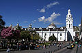
Metropolitan Cathedral built in 1535.
St. Francis Church before the 1868 earthquake.
One of the clouds of the San Francisco convent.
Old hospital of mercy built in 1565.
St. Augustine Church planned in 1581.
St. Domingos Church built in 1581.
17th century
The city of six hundred is the expansion at the feet of Pichincha and the squeezing of new religious centers. With the difference of the major urban centers such as the city of Mexico and Lima, Quito conserved a provincial air characterized by the uniformity of the narrow and stacked streets and wide squares (Plaza Grande, São Francisco Square and São Domingos Square), all framed by the green mountains of the Andes.
In the course of the seventeenth century, the maneuvering that began in the previous century continued to be vigorous along with mudéjà forms, visible in the clouds' galleries in the São Diego collection or in the convents of Santo Agostinho and São Domingos. The survival of this style is due to the presence of Jesuit architects born or trained in Italy. An example of this is inside the cannon dome of the Church of the Company of Jesus, the work of the Spanish architect Marcos Guerra in 1605.
Cannon pumpkin from the Company church.

Inside the Company church with the cannon cube introduced by architect Marcos Guerra.

Detail of the drawings of Arab influence on the abboda of the Jesuit Church.
One of the most important architects of this century was the Franciscan religious Frei Antonio Rodríguez. Between 1643 and 1647, he raised the convent of Santa Clara with a church made up of three ships, which is not very common in the temples of nuns. The construction of the Franciscan monastery of Guáops is also being attributed, a temple built on the outskirts of Quito, trapped on a small plateau that is to be found on the eastern hillsides of the great plateau of Quito. It was through this location that the Spanish conqueror Francisco de Orellana passed in 1541 during his expedition to the lowlands of the Amazon. The church was built between 1649 and 1653. The volcanic stone facade is a maneirist, and inside it a cannon dome was used with elements that come from the engravings of Sérlio. His work is also the chapel of Villacís, located inside the church of San Francisco. A ravine called Zanguña went down from the slope of the Pichincha massif, went below the El Tejar monastery and continued behind the cathedral. This ravine was stuffed in 1617. In 1694, the Spanish architect José Jaime Ortiz, from Alicante, arrived in Quito. He started building the temple. In the civil architecture, the Villacís family's house stands out, where the Colonial Art Museum and the Benalcázar house are now working.
Sanctuary of Guáple in honor of Our Lady of Guadalupe da Extremadura, Spain.

Guapulo Maneirists Fact.
Found of the church of El Sagrario.
17th century wooden gate with stone frame.
They will marry the Villacís family of the seventeenth century.
18th century
Since the mid-seventeenth century and throughout the eighteenth century, the baroque style in art and architecture has reached its climax. Sculptural decoration of native indigenous sources also served as an integral part of the interior and exterior of dozens of baroque churches built with an extravagant and exaggerated Churrigueresco way, in all the Spanish colonies at that moment. The best examples of this century are the facade of carved stone and the decoration of the dome of the Church of the Company of Jesus made by Venancio Gandolfi and Pedro Deubler in 1722, and of the inside of the chapter hall in the San Augustín convent. Solomon columns share space with fruit, leaves, cherubins and indigenous symbols. El Sagrario's boob and some of the puppets are surprising.
1786 Quito Plant.
Plaza Grande in 18th century oil.
Church fake of the Company of Jesus (1722).
18th century baroque gate in the convent of São Domingos.
Transition from 1800 to 1850
The beginnings of the 19th century did not represent for the capital many changes in the city's urban design. Baron Luis Héctor de Carondelet brought the Spanish architect Antonio García to transform the ancient palace of Quito's audience. At that time, the dome was also constructed and the cathedral staircase, which today are the icon of the main church.
The civil constructions continued with the colonial model without much change in either style or material.
Since 1808, the Royal Audience of Quito has lived through the fights for independence that ended in 1822 with the battle of Pichincha and the annexation to the Republic of Great Colombia that lasted until 1830.
Plant from the city of 1810.
Carondelet palace in 1845 at Rafael Salas's painter.
Archbishop Palace of Quito - Anonymous (19th century).
New political and urban order: 1850 - 1908
In the mid-nineteenth century, after independence, Latin American architecture as a whole turned to historical styles of French inspiration. This change reflected France's cultural dominance across Europe, especially in the technical academies where European architects were trained.
The neo-classical European model of different types is that the doors and windows arrive together with cornices and balconies supported on masonry beams, figurative overlaps of mud and plaster, especially with floral, semi-colon and pile representations incorporated into the facade, with preference for the openings of the raised floor.
Two events that marked the urban development of the city were the earthquakes of 1859 and 1868. The first was called the "Quito earthquake" and hit most of the city's religious buildings, particularly the towers of the churches that were cut down, which leads to the conclusion that the current finishes are republicans. However, all the reconstruction works were paralyzed by the IBarra earthquake that produces the collapse of the church tower of the Society of Jesus, which was 40 meters tall, the highest in Quito and recently repaired. Architect Thomas Reed decided to take her down.
Gabriel García Moreno, who was president of the Republic and led Ecuadorian politics for 15 years from 1860 to 1875, made several changes in the city. He's one of the rulers who owes the city of Quito the most. In 1859, the presidential palace was hit by a strong earthquake, and Moreno decided to remodel by adding two side wings on the front porch and in 1871 installed the public watch that still works. Besides, he brought it back to the Jesuits and restored the Church of the Company of Jesus that had been abandoned after the expulsion of order in 1767. He founded the college of São Gabriel (1862), the School of Arts and Crafts (1897), the National Music Conservatory, the prison (later named Criminal García Moreno) and the Astronomical Observatory.
For all these works García Moreno hired the services of several foreign professionals such as the architects Thomas Reed (English), Francisco Schmidth and Jacobo Elbert (German) and Leopoldo Grivillers (French) and the engineers Sebastião Wisse and A. Millet (also French), besides Mac Clellan and Davis, the Americans. In 1873, he hired the French architect Emile Tarlier to draw up the plans for the Basilica of the National Vote, although the architect never came to Quito. He only sent the plans, but the work stopped due to the assassination of the president in 1875 and was resumed in 1892.
During the government of General Ignacio de Ventimilla, the most important work was the construction of the Sucre National Theater, led by the architect Francisco Schmidth and finished time after the overthrow of the general in 1887.
Astronomical Observatory, the work of the German Jesuit Johan Batiste Menten in 1873.
National Sucre Theater around 1890.
Basilica of the National Vote and in front of Gabriel García Moreno's statue.
Begins of modernity: 1908-1930

Two major events contribute to changing the country's physiognomy by encouraging the economy in general and exporting and importer trade in particular: the arrival of the train to Quito in 1908 and the opening of the Panama Canal in 1914, facts that also determine changes in the city of Quito.
In 1895, he transformed the Liberal Revolution, led by General Eloy Alfaro, who brought modernity to this Andean country. The most important work of liberalism was the completion of the railroad that brought together the towns of Guayaquil and Quito and which was initiated by García Moreno. On June 17, 1908, the train arrived in the capital city. The station was built south, in the area called Chimbacalle. The daily service started on June 25 and along with this event, a migration flow also started.
In 1890, a path was built to unite the ancient parishes of La Magdalena and Chillogallo, both located to the south of the Panecillo hill. This new road was the beginning of the growth of the city to the south.
European migration, specifically from Italians, Germans and English in this period, is important because they have left their impression on several neoclassical works. However, at the end of the 19th century, new Ecuadorian architects emerged, some working together with foreigners of neoclassical and eclectic ideas. Some of them were: Gualberto Pérez, E. Come on, Vasconez, A. Velasco, Lino M. Flor y Juan Pablo Sanz. J. Gualberto Pérez Eguiguren (1857-1929) was the most notable, extremely important professional and a quintessentially graduate, graduated in 1887 as a civil engineer at the Polytechnic School created years ago by García Moreno. Author of several projects, such as the market of Santa Clara (1897) together with Schmidt. He was active as a professional in Quito until the 1920s. It is also important to know that the same year of his graduation (1887) carried out the most precise plant of the city of the nineteenth century with the "drawings of all his houses", owned by the city hall of Quito and is considered the first survey of the city's register. It was a plant much used in the aftermath and was only added to the original new projects, such as the creation of the São Domingos Square garden and the Mariscal Sucre statue, inaugurated in 1893, as well as the proposal for the construction of Mayo Avenue 24, which was concluded in 1922.
Between 1899 and 1904, the construction of the new Market took place in the square located in front of the convent of Santa Clara. The metal structure was brought from Hamburg and it had the style of the Gustavo Eiffel works. At the same time, the president of the municipality Francisco Andrade Marín made the ancient ravine of Jerusalem fill in to transform it into the boulevard 24 de Mayo, a name placed in honor of the date of the battle of Pichincha.
In 1894, Manuel Jijón Larrea and Julio Urrutia obtained municipal permission and a concession for 15 years to install electric light. In 1895, the service began on the most important streets of the city center, and in 1908 an energy plant was set up in Guapops.
For the commemoration of the first centenary of Quito's first attempt at independence on August 10, 1909, General Alfaro inaugurated a universal exhibition in the modern Exhibition Palace, which afterwards became the headquarters of the Ministry of Defense. The building was the work of the Portuguese architect Raúl Maria Pereira. Furthermore, the monument to independence was also inaugurated in the main square. To this end, the Italian sculptor Jean Batista Minghetti and the architects Francesco and Lorenzo Durini were hired.
In 1914, the first line of the electric bus was inaugurated and worked until the 50s.
In 1902, the National Congress began its first water-pipes to the city. For 1915, German engineer Schuatter designed and constructed the Water Purification Center of El Placer, in the same place where, according to the historians, a part of the ancient palace of Inca Atahualpa was located.
Since the end of the 19th century and early 20th century, the city has spread to the south in the areas of San Diego and Chimbacalle and to the north in the current neighborhood of La Mariscal.
In the 1920s, the first residential sets began to be planned outside the urban perimeter. The "Citizen Mariscal Sucre" was the first of these projects. The construction work was carried out by V.E. Road. It has been reported as a modern, comfortable, accessible "garden city" under the motto "Old quito will be the business empire, the garden city will be the empire of the new Quito for pleasant, hygienic and quiet residence"
La Mariscal gets his name from the celebration of the centenary of the battle of Pichincha (1922) and had an extension of 130 hectares. The barracks were regular and some houses occupied a quartet.
In 1919, America was also planned, located on the west side of the Ejido park. The civil engineering and architecture firm Álvarez & Donoso designed the houses and the town from a pan and a central square where the church of Perpetuo Socorro was built. The town was built on 378 plots of land, each quarter of which had room for eight houses.
The city grew to Colón Avenue, where the racetrack was built and at the same time the ancient Iñaquito plain, located in the northern area, was the first runway for landing and taking off airplanes. On November 28, he checked the first plane purchased by José Abel Castillo, owner of the newspaper El Telégrafo de Guayaquil and led by the Italian pilot Elia Liut.
Important buildings of this period are the former Central Bank (1922), and the Najas Palace (1923), both drawn in eclectic style by the Durini brothers.
Project of the Najas Palace, presented in 1923.
Najas Palace in 1930.
Project for the Pichincha Bank in 1916, which afterwards was purchased by the Central Bank of Ecuador in 1922.
La Circasiana Palace, built by Francisco Schmidt for Count Jacinto Jijón y Caamaño.
Francisco Schmidt by L Labaure (1874).
Rationalism and regionalism: 1930
During the period between the economic crisis of the New York stock market until the end of World War II, the city experienced intense changes. Broad avenues and new parks and squares were added to the urban section of the capital.
The eclectic styles, Art Déco and Art Nouveau have come to terms with the foreign influence. Several Italian architects such as Antonio Russo and Rubén Vinci shared Quito's new architectural scenario with Ecuadorian professionals such as Alfonso Calderón (1905-1948), Eduardo Mena (1898-1975), Leonardo Arcos (1906-1977) and Luis Eguez and Aduardo Pólit, among others. The nationals were contrary to foreign symbolism and presented proposals with a neo-colonial tendency with the use of stone in the facades and spaces that remembered the colonial architecture.
However, rationalism was the solution of the new architecture and urban planning.
The Italians joined German architects like Augusto Ridder, who arrived in Ecuador in 1909 and was the diretor of public works in 1936. Some of his most emblematic works were the Post Office Palace (1927), today the Vice-Presidency of the Republic and the Teatro Cumandá. He also directed the construction of the Bolívar Theater (1931-1933), starting from the project of the American company Hoffman & Henon.
Another very important German was Pedro Brüning (1869-1938), who carried out three works of interest: the chapel of the San Diego cemetery (1935) and the doorway of the cemetery (1936) of the neoclassical type; and the chapel of San José within the Mariana de Jesús College (1932) and the church of San Roque (1925). Architect Guilhermo Sphar arrived in Ecuador in 1923 for the Mejía College drawing.
The former Hildago Palace was reformulated by Antonio Russo in 1930 for the Majestic Hotel.

Gangotena Palace reformulated in 1914 by Antonio Russo.
Former Central University of Ecuador, building reformulated after the 1929 fire.
Art Nouveau-style staircases from the former Central University.
Mejía National Institute, work of Guilhermo Sphar.
The chapel of the San Diego Cemetery, Brüning's work.
Found of the Bolívar Theater, by Hoffman & Henon.
The Uruguayan influence and progression: 1940-1950.
In 1932, the Central University of Ecuador established the Faculty of Architecture. In 1940, he visited Ecuador and the Uruguayan architect Armando Acosta y Lara to present some lectures at the college about the functioning and progress of the Montevideo School of Architecture. In those days, the Uruguayan architect Jones Odriozola was on a journey, and in 1947 he presented the Regulatory Plan for Quito, in which he established the new expansion areas and tried to organize a new kind of urban planning.
With the drawing up of this plan, the Uruguayan also arrived Gilberto Gatto Sobral (1910-1978), a descendent of Italians, who with his fellow countrymen worked with Ecuadorian engineers like Luis Tufiño and Wilfrido Moreno Loor.
University City was the most important project of Odriozola and Gatto Sobral. The construction of the new campus began in 1944 and was the beginning of the growth of the city to the north on the banks of the Pichincha volcano.
Overview of the north wing of Central University.
Indoamerica Square and University Theater, work of Gilberto Gatto Sobral, 1947-1949.
Law School 1948-1950.
First skyscrapers: 1950-1970
A substantial increase in growth, from the 1950s onwards, was accompanied by changes in the vision of architecture that moved away from the eclectic and neoclassical models. New technologies and materials, and new expressive and functional codes have come about in high-rise buildings that have broken the city's horizon, even though it has not been in quantity and size to unlink the urban trait of the center.
The pioneers of modern architecture were Europeans who migrated from Europe as a consequence of World War II. Amongst the most famous are Carlos Kohn (1894-1979), Otto Glass (1903-1976), Giovanni Rotta (1899-1966), Óscar Etwanick (1892-1957) and Edwin Aller (1) 1915-?
The Olympic Stadium Atahualpa was built between 1948 and 1951 by the architect Etwanick to the north of the city as part of the plans for expansion.
President Camilo Ponce Enríquez and his Minister of Public Works, Sixto Durán Ballén, with reason for having chosen Quito as the seat of the 11th InterAmerican Conference of Chancellors that was to be held in 1959, but never materialized, impeded several works together with the company Mena Atlas, the American Charles Mac Hiraham and the Ecuadorian Oudan swaldo de la Torre.
A representative work of that time is the building of the Social Welfare Institute (1957-1960), designed by the architects Sixto Durán Ballén, Gatto Sobral, Eduardo Gortaire and the engineers Leopoldo Moreno Loor and Oswaldo Arroyo. This building is considered the first work built by the state of importance in the modernism of the second half of the 20th century.
The Legislative Palace was constructed between 1956 and 1960, the Hotel Quito between 1956 and 1960 and the former International Airport. Between 1956 and 1959, another icon was the building of the automobile dealer Casa Baca, built in 1950 by Etwanick.
At the beginning of the 60s, the international style was consolidated with more works in the public sector, as in the Loan Bank building at the Historical Center drawn by architect Ramiro Pérez Martínez, who later drew the Central Bank of Ecuador where the courtain wall was used and where an urban project was carried out in which the square on the corner of the building, with garden zones. The 1960s was very complicated in Ecuadorian politics because there was instability and a fall in banana prices that was the main export at that time.
Between 1956 and 1960, the French architect René Dénis was invited by Benjamín Carrión to draw up the new headquarters of the Ecuadorian House of Culture. The building finally began to be built in 1975, even though it was finished recently in 1992. Here you can find the National Library, the National Theater, museum spaces, a time and several theater rooms. The Prometeo Theater, built between 1962 and 1970 by architect and artist Oswaldo Muñoz Mariño, is one of the works that were also emblematic of that time.
The city after oil and post-modernism: 1970-1980
At the beginning of the 1970s, he had a military coup against the fifth period of President José María Velasco IBarra, led by General Guillermo Rodríguez Lara, who is going to nationalize some companies like the oil tanker, and with this a time of economic development and construction began.
18- and 20-story buildings were built in a capital city that became cosmopolitan and moved away from the former colonial settlement. In these years we have several architects of the old guard who build buildings that are very important for banking, public and private institutions like Luis Oleas, Milton Barragán, Ovidio Wappenstein, Fabián Zabala and Mario Zambrano.
Other architects who also built high-rise residential buildings were Alfredo Rivadeneira, Diego Ponce and the Banderas Vela brothers, using new materials such as reinforced concrete and brick.
The city of the new millennium
A new generation of architects born between 1950 and 1960 continued the transformation of the Ecuadorian capital. Brothers Handel and Gustavo Guayasamín were the authors of important buildings, besides Ciudad Quitumbe planned for the south of the city as a new administrative, commercial and service center and the Metropolitan Park inaugurated in 1995. Other authors are Fernando Hinojosa, Alexis Mosquera and José María Sáez.
Between 1970 and 1980, another generation of architects began to be built at the end of the 1990s and at the beginning of the new millennium. Some of them are Diez Muller Architects, Adián Moreno, Christian Wiesse, Pablo Moreira, Felipe Correa, David Barragán and Pascual Gangotena, among others.
The expansion of the capital to the north and to the south has made the authorities look for new alternatives to improve the infrastructure and public transport. In 1995, the trolley bus or electric bus system was built with more than 20 km from north to south and six lines. Other public transport systems are Ecovia and Metrobus. It is currently beginning to construct the first subway system in Ecuador.
New residential buildings north of Quito.
Avenida Amazonas in the neighborhood of La Mariscal.
Building of the General Commandance of the National Police.
Urban picture of Quito in 2011.
Demographics
The South is characterized by high commercial activity. In the Chillogallo parish, one of the largest in the capital, business proliferates in all parts, above all restaurants and hardware stores. You can taste from the traditional roasted chicken to dishes typical of Ecuador like guatite, ceviche, dry whipping or fried. In the south, besides that, there is the industrial park of the city and the Trens Station of Chimbacalle.
In the center, the streets are narrow, which is why access to vehicles is restricted during weekends. The colonial architecture is very calling, above all its large churches. The municipality has developed a restoration plan for the colonial buildings.
The northern Quito area is the city's financial and banking center. The matrixes of many of the major banks operating in Ecuador are located in this part of the city, as are other major financial entities such as the Quito Stock Exchange, the Central Bank of Ecuador, the Internal Rent Service, the Superintendent of Banks, among others.
The area collimated with the historic center has developed a series of high-rise skyscrapers and high towers, the highest of which is the National Basilica, with a height of 36 stories and a miracle for the city of Quito. The buildings of the Financial Corporation, the Corpei Tower, the August Diez Tower, the Benalcázar Building Thousand or the Provincial Council are some of the Kenyan skyscrapers that exceed twenty stories. Many of the northern districts are residential in nature and trade is concentrated around the Iñaquito area.
The area in which the city's bars, cafés, discotheques, casinos, karaoke etc. are concentrated is the so-called Plaza Foch area, in the La Mariscal sector, where the young chitera and other parts of the world enjoy multiple open-air terraces to drink a glass of wine.
Transport
Air
The Sucre Mariscal International Airport serving the city of Quito was opened in 1960. It has a runway of 3 120 meters in length and an important cold infrastructure for the maintenance and storage of flowers and other perishable goods for export. The airport is located in Chaupicruz, just 10 minutes from the city's commercial area. In 2002, the refurbishment of this air terminal started and was completed in August 2003. Today, this area has all the typical services and amenities of an international airport. The connecting facilities are multiple by direct flights to Madrid, Amsterdam, Bogotá, Medellín, Lima, Santiago, Buenos Aires, Panama City, Caracas, San José, Bonaire, Miami, Houston, New York, Atlanta and with brief connections in Mexico, Rio de Janeiro, São Paulo, among others.
The location of this airport in the metropolitan area has caused many problems for citizens, including aircraft noise and the fact that they are unable to construct buildings exceeding 100 meters. As a result, the construction of the new airport in Quito, which is located near the city in Tababela, is being carried out at the same time, and will start operating from 2012. The new terminal will be equipped with services and installations of first class and with a capacity of more than 5 million passengers per year and 270 000 tons of cargo, carrying out an average of 44 operations per hour. The current airport in Quito will become a large park and a green lung for the city.
Tourism
| ||||
|---|---|---|---|---|
| UNESCO World Heritage Site | ||||
| Historic Center of Quito with the Basilica of the National Vote in the background. | ||||
| Country | ||||
| Criteria | C(ii)(iv) | |||
| Reference | 2 en fr | |||
| Coordinates | 14' S 78° 30' W | |||
| Subscription History | ||||
| Enrollment | 1978 (second sitting) | |||
| * Name as listed on World Heritage List. | ||||
According to the Metropolitan Tourist Development Management Company of Quito, in 2014 682,429 tourists arrived, 8.5% more than in 2013.
The main tourist markets for Quito are:
| Issuing country | Tourists |
|---|---|
| 144 074 | |
| 87.959 | |
| 70.214 | |
| 41.913 | |
| 20.624 | |
| 20.611 | |
| 19.225 | |
| 18.998 | |
| 17.184 | |
| 13,032 |
Hotels
In the Metropolitan District, 653 hosting sites are registered, cataloged at: luxury, first, second, third and fourth categories. Third-party leaders lead the group, with 342 sites. The city has nine luxury housing and 97 first-class accommodation establishments.
Tourist sites
Churches and property temples
Metropolitan Cathedral of Quito
It is impossible to visit Plaza Grande and not to be surprised by the imponence and beauty of this eclectic-style religious temple, built between 1535 and 1567. Regarded as the oldest in South America, the cathedral is a curious mixture of architectural styles, with gothic arcs, the golden ceiling and baroque ships.
Church of the company of Jesus
Anyone who walks through the facade of this baroque church made from stones of volcanic origin cannot imagine the beauty of its interior, where thousands of gold leaves are to be found scattered along the altar and corridors. Constructed by the indigenous people, with the guidance of Jesuit priests, the work took 160 years to be concluded, in 1765, and is considered the apex of the baroque in Latin America. The temple has already undergone different transformations due to the earthquakes of 1868 and 1987, as well as a fire in 1996, which altered part of the dome and of the retable of São Francisco. Even so, the visitor is surprised by the beauty of the work carried out with gold bread in its internal structure. Look at the discrete indigenous influences, like the Inca cross drawn on the pillars, and the geometric drawings of Arab influence. In the Altar-Mor, you find a big mirror on the floor to appreciate the drawings of the church dome. The entrance to the site includes the accompaniment of a guide that, although providing some controversial information, assists in understanding the history of this church. The tour also passes through a room with paintings from the 17th and 18th centuries, located in the church sacristia and a small exhibition of bells used in the church towers.
Convent of San Francisco
Considered to be the oldest church in Quito built in 1535 by the religious men of Belgian origin Frei Jodoco Rijcke and Frei Pedro Gosseal, this white-walled temple, located in the beautiful São Francisco Square, has entrance carved of stone, baroque interior and roof covered with gold bread. The archeological work carried out on the site rescued pre-Columbian objects, such as ceramics manufactured before the arrival of the Inca. The Fray Pedro Gosseal Museum is installed inside the church that name the site. This museum brings together colonial art from the sixteenth, seventeenth and eighteenth centuries and houses one of the most important collections of sacred art throughout the continent. Many of the works that are currently spread all over the city have come from the Santo Andrés College of Art and Sculpture, an artistic school that worked within the clouds of the convent of the Franciscan priests, where the museum is located. The current collection is made up of paintings and sculptures created during the 16th century of the Quiteña Clothes.
Convento de São Domingos
Its construction began in 1580, by the Spanish architect Francisco Becerra, famous for having constructed the cathedrals of Puebla in Mexico and Lima and Cusco in Peru. It's considered one of the most important in the city, because of the magnificence of the church ceiling all decorated with a bull style.

Basilica of Our Lady of the Mercy
Another example of colonial religious architecture. Built in 1700, the complex is a display of baroque, maneirist and other influences. In the main claustrum lies the wonderful source of Neptune, the god of the waters.
Convento de Santa Catalina
Built in the 17th century, this nun convent still retains its original architecture. The nuns live in enclosures and the only way to contact the mundane people is through a wooden lake where the customer buys some of the natural products they make.
Convent of Saint Augustine

Designed by the famous Spanish architect Antônio Becerra in 1580, he is one of the most beautiful examples of the British baroque. The ceiling of the corridors has a craftsmanship of 1660 decorated with diamonds that have corn ears covered with gold. The Capitular Room was declared a national monument because it was the place for the declaration of independence of Quito in 1809.
Church of El Sagrario
This church, which began to be built in 1694, has a renaissance style and is connected to the Cathedral. The incredible one is that wooden gate carved from cedar covered with gold leaves, from the 18th century.
St. Diego Collection
This is a unique and unforgivable experience for those who visit Quito and like to dive into colonial history. The curious visitors have the opportunity to come in and meet a 17th-century convent and sneak into those small cells where the Franciscan priests lived.
Brazil's National Vote
From all parts of Quito it is possible to see this gothic construction, erected between 1892 and 1909, considered to be the largest church in Ecuador. However, the best view is that of the inside of its immense towers, which reach 117 meters in height. The climb by narrow, often vertical stairs does not attract the least adventurers, but the brave are rewarded with panoramic views not only of the Basilica itself, but of the whole city. On solid ground, the visitor can still see the beautiful inside of the temple.

Museums and History
Rumipamba Ecological and Archeological Park
The pre-Colombian past of Ecuador is represented in this 32-hectare park, whose attractions are the archeological vestiges found in the site in 2001. The extensive collection includes objects from the year 1500 BC. as ceramics, at 1500 d.C., like the remains of villages and tombs built during the Integration Period. Evidence of the passage of civilizations prior to the arrival of the Spaniards also includes material produced by the Inca.
Metropolitan Cultural Center
In 1622, the museum Alberto Mena Caamaño, a space dedicated to the reconstruction of important periods in the history of Ecuador as its independence, whose bicentenary was celebrated as its bicentennial of 2009, was the University of São Gregório Magno, the largest center of higher education in the Jesuits. The current exhibition is made up of 39 wax dolls that represent important figures for the country, reproduction of objects and works of art from the colonial period. The museum also offers a room for the visually impaired, where visitors find panels in Braille and objects that can be touched. Temporary library and exhibitions are other cultural options offered on-site. The building where this cultural center is located, the building of which was the scene of a bloody massacre of the Pakistani patriots in 1810.
National Museum of Ecuador
The highlight of this museum is the rich archeological collection formed by objects from the Pre-Ceramic era (10000 BC) and the masks made up of gold used in ancient ceremonies. As it could not be lacking, Inca civilization also has its reserved area. Created by the Central Bank in 1961 and today administered by the Ministry of Culture, it is considered one of the largest museums in Latin America. Since November 2014, the museum has been closed for renovation until 2016.
City Museum
Located in the oldest construction of Quito in 1565, this museum is dedicated to the history of the Ecuadorian capital between the sixteenth and nineteenth centuries. Its five permanent rooms recount historical facts of the city such as its foundation, the influences of baroque culture and French customs in daily life. Another three museums are on the site: The Chapel of Our Lady of the Angels, the Church of the Hospital and the Eugenio Espejo Room.
Quito Contemporary Art Center
Located in a building built more than 100 years ago, where the Military Hospital of Quito worked, this cultural center offers visitors various exhibition rooms of modern and contemporary art in Ecuador and the world.
Man's chapel
The same house where the Ecuadorian painter Oswaldo Guayasamín lived houses a tree under which the painter and his best friend, writer and poet Jorge Enrique Adoum, were buried in his garden. Next to the garden is a building that was designed by the artist as a tribute to the peoples of Latin America. The Capela do Homem (The Capela of Man) is able to count on the artist's own works, as murals that represent the history of humanity.
Camilo Egas Museum
Since 2003, the adobe walls of this ancient colonial house have housed the works of Camilo Egas, an artist who took part in the realistic movement and who had an influence on expressionism, surrealism, cubism and abstract art. The rooms, divided according to the artistic moment of Egas, also show works with evident indigenist influences.
Mindalae Craft Museum
The theme of this ethno-historical museum is the artisanal works carried out all over Ecuador, as well as its materials and techniques. Located in an area of 1,700 meters, the collection can count on works by indigenous peoples, Afro-Ecuadorians and half-breeds. One of the highlights of this beautiful and complete museum is its modern building equipped with the `Ojo de Sol', a sort of skylight that illuminates, naturally, part of the five floors of the site. The exhibition rooms are divided into: Shamanism, Cosmovision Andina, Dress, Ceramics, Natural Fibers and Amazon Worlds.
Parks and squares
Plaza Grande
Anyone who has ever visited a large Hispanic city has met the most famous trio: government cathedral square. Popular squares in Spanish-speaking Latin American countries are usually not only a meeting place, but one of the main tourist spots in these cities. In Quito, it could not be different. The rhythm in the main square, usually called Plaza de la Independencia, does not stop all day, and goes so far as to recall the flight and comes frantic from the major Brazilian urban centers, but it is at night that Plaza de la Independencia, as it is known, gains a capricious illumination that invites locals and visitors from abroad to spend a good time there. Children running between gardens, couples of boyfriends sitting in the banquets and tourists recording the beleaguered beauties of the Cathedral and the Presidential palaces, Archbishop and Municipal. Another highlight of the Great Square is the Monument to the heroes of Independence, inaugurated in 1909, in homage to the first centenary of the country's independence. In the days of very clear skies, it is possible to see how the blue of the fifteenth sky breaks down because of the Pichincha volcano.
St. Domingos Square

This beautiful square, located in the historical center of Quito, was built in the sixteenth century and houses attractions such as the Santo Domingo Monastery, colonial shrimps and a statue in honor of Antonio José de Sucre, responsible for the independence of Ecuador. The location has already been Quito's main entrance. The square is one of the main accesses to Calle La Ronda, a Bohemian street where art and handicraft galleries, bars and restaurants are concentrated.
San Francisco Square
This is one of the largest and most beautiful squares in the whole city. Built with a volcanic stone, the São Francisco Square is surrounded by shrimps well preserved from the period of the country's independence and by the São Francisco Church, considered to be the oldest church in Quito. The place has already served as an area for an Inca market, known by the Spaniards as Tianguez, and for temples and palaces of the same time.
Alameda Park
It's the oldest park in the city, created by the Spaniards in the sixteenth century. Inside the park is the Astronomical Observatory of Quito. Together with the Córdoba observatory, in Argentina, this is considered one of the oldest astronomy study centers in South America and was founded in 1873. The site was reopened recently after undergoing a restoration process that took two years. On the nights of the clear sky, it is possible to observe stars and planets with a telescope of up to eight thousand times of amplification available for tourist purposes, considered to be the largest in the country. The visitor may also meet a small museum dedicated to astronomy and the first seismological and meteorological stations in Ecuador.
Itchimbía Park
During the pre-Columbian era, this hill was considered sacred to the indigenous. Today it is a park that houses the Paço de Cristal, a former market built in 1904 in Hamburg and set up in the old center, but transferred here and converted into a cultural center. It has a wonderful view of the historic city.
La Carolina Park
It's one of the largest parks in the city, located in the modern city, surrounded by shopping centers, shops, and the financial heart of Quito. Inside the park is the Botanical Garden, with incredible species of Ecuadorian orchids, the Natural Sciences Museum and the Vivarium.
Theaters
Sucre National Theater
Designed by a German architect, this theater of the late nineteenth century, a remnant of the European opera houses, is considered one of the architectural icons of Quito by its neoclassical style. Today is the permanent headquarters of the National Symphony Orchestra.
Bolívar Theater

A masterpiece from the 1930s was inaugurated with the movie "The Sign of the Cross". For decades, it was one of the greatest scenarios of Ecuador for cinema and theater. In 1997, a fire struck a large part of the structure, but the Bolívar Theater Foundation is in charge of restoring this marvelous room that, even when burned, continues to house marvelous plays and opera.
National Theater of the House of Culture
It's the city's main venue for shows. It is inside the Ecuadorian House of Culture complex. It's used for the performance of famous national and foreign artists, as well as ballet and opera.
Capitol Theater
Building built in 1908 by Italian Giacomo Radiconcini and transformed in 1937 into the Cadena Theater by Italian Antonio Russo and finally into Capitol Theater. Since 2008, studies have begun for the restoration, and in 2014 it was inaugurated completely.
Varieties Theater
Building built between 1913 and 1914 by Giacomo Radiconcini. It's a theater dedicated to the presentation of music, dance to theatrical plays of different genres.
Mirantes or mirrors
El Panecillo
Several monuments relate Brazil to Ecuador. While Rio de Janeiro has its famous Christ Redeemer, considered one of the new seven wonders of the world, the Chitorns pride themselves in possessing a statue of the Immaculate Virgin larger than Christ and considered a patron of the city. However, the "Wonderful City" has another monument that rivals Quito. This is the Pão de Sugarcane hill, larger than a five-tenth hill called "Panecillo", which means bread and on whose top, located more than three thousand meters above sea level, the sculpture of the Imaculada Virgin is 45 meters high and was constructed, by a Spanish artist in 1974, with more than seven thousand pieces of aluminum. From inside it, you can see the whole city.
San Juan
It is a miracle located on one of the most representative hills of the historic center and where the San Juan district is located. Here you can see a panoramic view of the ancient city, as well as a part of the volcanoe Avenue to the south. Antisan, Cotopaxi and Ilinizas can be admired.
Operator
This is the most recommended attraction for those who want to know Quito and his impressive volcanoes from another point of view, but without much effort. Located more than 4,000 meters in height, in the cerro Cruz Loma, this tourist complex offers an overview of the city and of the volcanoes of the region such as the Cayambe (5,790 m), the Antisana (5,700 m), the Cotopaxi (5,897 m) and the Rucu Pichincha (5,790 m). The route from the cable car to the main rim lasts ten minutes and is 2.5 km long. The place also has coffee shop and a souvenir shop.
Tourist City Half the World
The site, known as 'Ciudad Mitad del Mundo', is a replica of an ancient Ecuadorian colonial town that brings together attractions such as a nine-story, mirroring ethnographic museum, a planetarium with 35-minute daily performances, and three pavilions with archeological and scientific objects. The Equatorial Monument is one of the park's highlights. This construction, in the form of a quadrangular pyramid, has its sides focused on the four cardiac points and was built on the place that until recently had been believed to be the latitude 0° of the planet. However, it has already been concluded that the imaginary line that divides the northern and southern hemispheres is at least 200 meters further on. Even so, tourists from all over the world don't stop having fun taking the classic photos with one foot on each of the hemispheres. Another interesting attraction is the small museum that holds a model that represents the historic center of Quito with perfect replicas of the main historical points of the city and that is activated, every hour, with a small presentation of sounds and lights. It is worth coming on Saturday and Sunday because there are dance and music presentations starting at noon.
Cloudy woods Mindo-Nambillo
To the northwest of Quito lies the cloudy forest on the western hillsides of the Andes mountain range. This script contains magic waterfalls that were considered sacred by the ancient civilizations that lived on these lands. It's paradise for those who like birds like the roundcock and more than 100 species of hummingbird. Ecuador has more than 4 000 varieties of orchids, most of which are found in the Amazon and in the forest. There's a lot of adventure and fun. Adventure sports such as kayaking, tubbing, canopy, bike or riding are the offers of the northwest of Quito.
Sacred Valley of Tulipe
More than a thousand years ago, the northwest of Quito was a region where the indigenous people of the Yumbo civilization lived. They were merchants and wise astronomers who maintained an ative trade between the coast, the Andes and the Amazon. They built many ways to connect their villages. In the middle of one of the tracks, in a cloudy tropical valley surrounded by hills, the yumbos built their ceremonial center. From the 1980s, a group of Ecuadorian archeologists made the discovery, and after a long process of digging and restoring, they managed to recover some mysterious pools used for rituals and ceremonies.
Pedro Vicente Maldonado
Only two hours to the northwest of Quito is the village of Pedro Vicente Maldonado, surrounded by the forest of the Andean cloudy forest and located inside one of the most megadiverse places on the planet with more than 35 species of plants, 664 of amphibians, and more than 500 of birds.
Culture
Art
Pre-Colombian Art
The first artistic demonstrations were found in Quito in the Cotocolao district in the 1970s. The oldest ceramics date from a historical period known as formative (1800 BC). The inhabitants of this civilization shaped the clay to make plates, bottles and tingles. They highlight the bottles with a stratum shaped handle, possibly influencing Machalilla's coastal culture. The cotochleas also worked rocks such as obsidian, quartz and green pedernal.
The stone containers have decoration based on incisions and sockets. The funeral offerings included ceramic pots. The ceramics were characterized by the color red or brown ash, very polished and with reasons that are very similar to the coastal cultures of Machalilla and Chorrera.
The ancient inhabitants of Quito were skilled weavers. A test is to be found in the necropolis of La Florida (100-700 d.C.), where some mummies were recovered, dressed with ponchs made with thin cut-and-polished scents of Spondylus princeps shell. They highlight the geometric designs associated with the indigenous cosmos. In the goldsmiths' shops, necklaces, earrings, rings and other decorations made with gold and copper have been found in an alloy called tumbaga, which is possibly influenced by the Pasto culture of the north of the current Ecuador.
Ceramic cylinder with Cotocolao bridge handle (1800 BC)
Bottle with Cotocolao Stribo handle (1800 BC)
Cotocolao Stone (1800 BC)
Red ceramic wagon in a tomb of La Florida (100 B.C.)
Paste of thin polished spondylus from La Florida (100 B.C.)
Broche called the gold tupu in the form of a La Florida monkey (100 AD)
Tupus with a circular gold shape from La Florida (100 B.C.)
Colonial Art
Although Quito is far from the great economic and political power centers of Spanish America such as Mexico, Bogotá or Lima, his isolation between the Andes mountains and the ability of his indigenous craftsmen for millennia has made the Ecuadorian capital an interesting laboratory of colonial plastic arts uncompared on the continent, with the exception of only Cusco and Guatemala.
Since the middle of the sixteenth century, the first artists formed by the Franciscans have appeared. The painting was influenced by works brought from Spain such as screens and engravings. Renaissance, maneuvering and baroque were the styles imposed during the first two centuries of colonial life. Works by painters Bartolomé Esteban Murillo and Francisco de Zurbarán have arrived together with sculptures by the svillain Juan Martínez Montañez, Alonso Cano and Pedro de Mena.
During the seventeenth and eighteenth centuries, Quito lived through an explosion of artists, painters, sculptors, goldsmiths, goldsmiths and banists that this artistic movement is known by some historians as the "QuitPassword School."
16th century: Renaissance and mannerism.
The first European works of art came from the hand of religious orders. In 1551, Franciscans of Belgian origin Frei Jocoko Rijcke and Frei Pedro Gosseal founded the São João Evangelista School within their convent, built in 1535. For 1557, he changed his name to the San Andrés School in honor of the viceroy of Peru, Andrés Hurtado de Mendoza.
Spanish sculptor Diego de Robles, from Toledo, is the main representative of this century's baroque sculpture. His masterpieces are the image of Our Lady of Guadeloupe for the sanctuary of Guapple (1584); Our Lady of El Quinche (1586) for the shrine of El Quinche and Our Lady of El Cisne (1586) in Loja.
Bogotá and Lima were the first teaching centers of European art in South America. The Italian masters Bernardo de Bitti, Mateo Pérez D'Alessio and Angelino Medoro were the teachers in charge of training the first American, indigenous and mixed-race artists.
One of the pioneers of the arts in Quito was the Dominican Pedro Bedón (1556-1621), studied in Lima and founder in 1606 of a convent in the current city of IBarra. For 1587, he dedicated himself to teaching painting to indigenous people. After the Alkabala rebellion in 1592 he traveled to Bogotá and Tunja, cities where he left several works of his own. There are also works of yours in Lima. He wrote the work Mode of promulgating el Evangelio to los indios de esto reinos and Instrucción para la administración de los Sacramento à los naturales of this Nuevo Mundo.
Andrés Sánchez Gallque studied at the Franciscan school and then at Pedro Bedón's school around 1687. His most famous work is the portrait Os negros de Esmeraldas (1599), which is to be found at the Museum of America in Madrid.
17th century: Change and baroque.
Hernando de la Cruz (1592-1646) was born in the city of Panama and studied in Lima. He arrived in Quito and decided to be a member of the Jesuit order. One of the works that keeps from him is the portrait of São Inácio de Loiola that is to be found in the sacristia at the Church of the Company of Jesus.
The most recognized mixed-race painter of the time was Miguel de Santiago (c. 1620-1706). One of his first works is a picture that represents The flagellation of Our Lord, dated 1646 and part of the collection of the National Museum of Ecuador. His mentor was the religious Frei Basilo de Ribera, who made him know the engravings of Dutch Schelte to Bolswert (1586-1659) about the life of Santo Agostinho de Hipona that he had to copy to decorate the galleries of the corridors of the convent of Quito. At the same time, it's possibly the first representation of Our Lady of the Immaculate Wool Concept, known as the "Apocalyptic Virgin." In the sanctuary of Guáops one can find the series of miracles of Our Lady of Guapple and in the Pedro Gosseal Museum of the Franciscan convent is the series of the Christian Doctrine.
Matheo Mexia was a painter who studied at the São João Evangelista School and left some works as a portrait of San Francisco dated 1619.
Nicolás Xavier Goríbar (ca. 1666-ca. 1740) was a disciple of Miguel de Santiago. Among his famous works are Our Lady of the Pilar (1688); a miniature of the Jesuit province of Quito (1718); a series of 17 screens representing the first children of the Franciscan order (1732) and the series of 17 prophets inspired by the Sacra Bible of Nicolás Pezzana that are to be found in the pillars of the Company's church.
The Italian and Moura influences are visible in monumental works such as the stone facade of the São Francisco church of the Maneirista and Herererian style. In the interior, he highlights the crafted change of wood and the chairs carved with the images of the Franciscan saints of the choir, made at the beginning of the seventeenth century, attributed to the Spaniards Sebastián de Ávila and Juan de Fuentes, as well as the craftsman of the church domo and the craftsman of the roof of the church of São Domingos.
Crafted by the church choir of San Francisco attributed to Sebastián de Ávila ca. 1610.
Crafted from the dome of the church of San Francisco attributed to Juan de Fuentes (1623-1624)
Crafted by the church of São Domingos, also attributed to Sebastián de Ávila ca. 1610.
Our Lady of Apocalypsis de Miguel de Santiago ca. 1647.
India spectacle exorcized during the Misa on the Altar of the Virgin of Guapple in 1646 by Miguel de Santiago.
King Manassés - Nicolás Javier Goribar (seventeenth century).
18th century: Baroque and rococo.
During the sixteenth and seventeenth centuries, a strong Andalusian influence marked the development of the colonial sculpture of Chitera, but from 1730 onwards, the Chithean sculpture baroque and rococo opened up its own language, adding in its repertoire medieval aspects of great interest, such as the systematic and abundant representation of winged beings: San Francisco, Santo Tomás, the Apocalyptic Virgin, or the countless angels and archangels that have shattered the churches' retables or the private altars. He also received Filipino influences in decorating blankets and tunnels.
Bernardo de Legarda y del Arco (ca. 1700-1773) is considered one of the most important and prolific colonial artists of Quito from the colonial era. He was a designer, a painter, a hooker, a goldsmith and a book illustrator. The artist's most famous masterpiece is the polychrome cedar wood sculpture of Our Lady of Quito, made in 1734 and preserved on the main altar of the Church of San Francisco. The image was inspired by the reports of Virgen apocalyptica and possibly by Miguel de Santiago's painting. Its works are preserved in several museums, churches and monasteries of Quito, Cuenca, Riobamba (Ecuador), as well as Tunja, Pasto and Popayán (now Colombia). Some of the most representative works are the wooden and gold division of the Church of El Sagrario, the Divine Pastor of the collection of the National Museum of Ecuador and the golden altar of the Church of the Quito Company (1735-1755).
Manuel Chili "Caspicara" was an indigenous man influenced by the sculptural tradition of Diego de Robles and Legarda. From his hand, there are presepios, calseveral and Cristos, as well as unique works like Our Lady of Light from the collection of the National Museum of Ecuador. One of the most famous works is The Sábana santa of the Metropolitan Cathedral.
In architecture, Pedro Deubler and Benancio Gandolfi have to be mentioned, authors of the facade-retabula of the Company's church, washed in volcanic stone. Highlight the sculptures and the Solomon columns.
Immaculate Concept of Popayán in the current Colombia of Legarda.
Our Lady Apocalyptica de Quito de Legarda (ca. 1734).
Golden from the main altar of the Company church, Legarda's work.
The Readable of Our Lady of the Pain with the sculpture of the Sábana Santa do Caspicara in the Metropolitan Cathedral.
St. Peter's Bust on the facade of the Company's church.

Stone strikeout of the Company church, the work of Leonardo Deubler and Benancio Gandolfi.
Detail of the cornices and salomonic columns of the Company's church facade.
The Albán family was one of the most prolific in the 18th century. Francisco Albán, born around 1720 and worked with Master Bernardo de Legarda at the wedding of the church of el Sagrario. For 1745, he worked at the company church. Vicente Albán, brother of the previous artist was born in Quito around 1725. In 1783, in a study commissioned by José Celestino Mutis (Spain, 1732-1808), one of the initiators of scientific knowledge in America and passionate about publicizing the botany of the region, carried out a series of six paintings to send to the Crown. They formed part of the collections of the Natural Sciences Museum in Madrid, afterwards they joined the Ethnographic Section of the National Archeological Museum until 1941 when they entered the Museum of Madrid, where they are currently to be found. In those paintings, he represents native and white in the foreground, surrounded by trees and fruit, with a numbered reference for the dissemination of the soil products of Quito. The works carried out with the technique of oil on the screen measure 109 cm in width by 80 cm in height.
Madam Principal with her black slave (1783).
Vicente Albán - Yndio yumbo de Maynas, with its load on the country's flora and fruit (1783).
Portrait of the bishop of Quito Manuel Blas (1783)
Cologne transition-independence
The two most representative artists of the late 18th century and early 19th century are Bernardo Rodríguez and Manuel de Samaniego. Both painters worked on the decoration of Matropolitan Cathedral. De Rodríguez highlights a collection of portraits of saints dating back to 1797 and belonging to the collection of the Museum of the convent of Santo Agostinho. Samaniego was probably born around 1767 and died in 1824. From his pictorial catalog, the paintings that are preserved in the Cathedral of Quito stand out: the worship of the Magus, the assumption of the Virgin, The birth of the Boy God and the sacrifice of São Justo and São Pastor. Other of his works are The Transit of the Virgin, shown in the convent of Santa Clara, and the series of prints titled Virtues and Defects of the European peoples (1788), of the collection of the National Museum of Colonial Art. He also wrote an interesting painting treaty.
19th century art
The 19th century was marked by the struggles of independence and the conformation of the Republic of Ecuador. Even though Ecuadorian thought still continued the strong presence of the Catholic religion and a culture of classes and very racist, the 19th century meant for the country the beginning of the construction of a national identity promoted mainly from the half-breed side and not only from the Spanish side that had been the dominant image of the colonial era.
Art and Independence
The first important event that marks the art of the time is the war of independence. In the midst of the libertarian struggles, artists could not remain outside these movements. The most important painter at that time was Antonio Salas Avilés (1780-1860), who, at the request of General Juan José Flores, the first President of Ecuador in 1830, made the portraits of several patriots.
Art and science
Quito has aroused the interest of scientists and travelers since the arrival of the French Geodetic Mission in 1736. The Chitanese painters were known not only for their ability, but for their docility. Neographically speaking physician José Celestino Mutis (1732-1808) organized the famous botanical mission called "Flora de Bogotá", which began in 1783 and lasted until 1817. This was an ambitious taxonomy project in which the brothers Antonio Cortés de Alcolcer (ca. 1750-1813) and Nicolás Cortés de Alcolcer (?-1816), Antonio de Silva, Vicente Sánchez and Antonio Barrionuevo were hired.
In 1870, the Germans Alphons Stübel and Wilhem Reiss arrived as part of a journey through South America. They hired a young painter born in IBarra who studied in Quito with the Jesuits. His name was Rafael Troya (1845-1920). Troya painted more than 800 "in situ" screens, the same ones that after being exhibited in Quito were taken to Germany where they were imprinted to illustrate Stübel ey Reiss's work "Ecuador's Stubs", which was published in Berlin in 1886. Some of these works are preserved in the Leipzig Grassi Museum, although others, most of them, disappeared or were stolen during the second world war.
Neoclassical and romantic
The end of the colonial era and the beginning of the 19th century meant the transition from the baroque rococo to a new style called the neoclassical one. The sculptor Gaspar Sangurima marked a new period, whose main works are to be found in the holy of the cathedral and in the convent of the Conceição in Cuenca. His new works were combined with Cristos baroque, requested by several private sectors. At the order of the Liberator Simón Bolívar, in 1822, Sangurima established the first School of Fine Arts in Ecuador, changing the dominant center of artistic production from Quito to Cuenca. José Miguel Vélez (1829-1890) was the continuation of this sculptural tradition.
Romanticism is represented in Ecuadorian art by numerous sculptures of which they represent popular personages of peoples and cities, a tradition that has been maintained since colonial times and that were used as part of the Preseppires.
Landscape and portrait also formed part of that time. Antonio Salguero Salas and Luis. A. Martínez is one of the most representative masters of that time.
20th century art
It was in the 20th century that Ecuadorian fine arts began to awaken. Social realism appears in the paintings and sculptures, taking the Andes indigenous and the mountainous part of the coast as protagonists.
Academicism
The academic background in Ecuador is at the foundation in 1849 of a Painting School, run by the French painter Ernest Charton and sponsored by the philanthropist Ángel Ubillús. On January 31, 1852, the Miguel de Santiago Democratic School was founded, in which the protagonists were artists Rafael Salas, Joaquín Pinto, Luis Cadena and Juan Manosalvas. The main objetive besides the arts was the defense of democracy and the opposition to the government of Juan José Flores.
During the government of President García Moreno, the Fine Arts School was created in 1872 under the direction of the painter Luis Cadena. However, the school lasted until the president was murdered in 1875. In 1904, during the government of the liberal general Leonidas Plaza and as part of the reforms to the state, this important teaching institute was reopened. In 1917, the Mariano Aguilera Award was created, which motivated the development of the fine arts throughout the country. Some foreign artists who influenced the arts in Quito were the Frenchman Paul Bar, the Spaniard José Maria Roura Oxandaberro and the German Hans Michaelson.
Indigenism
The first three decades of the 20th century, Ecuadorian intellectuals, inspired by Mexican muralists, by the indigenous movements and the growing social realism, created a movement called Indigenism. Rural and urban indigenous people were the main characters of paintings and sculptures. Some recognized were Camilo Egas (1899-1962), Eduardo Kingman (1913-1997), Diógenes Paredes (1910-1968) and the most widely publicized Oswaldo Guayasamín (1919-1999). (9)
National Artistic Vanguard
Around the 1960s, a group of artists identified with informalism created a movement known as the National Artistic Vanguard of the VAN Group. Among the artists were Enrique Tábara, Aníbal Villacís, Luis Molinari, Hugo Cifuentes, Gilberto Almeida and Stuardo Maldonado.
Ancestralism
The rediscovery of the pre-Columbian roots of Ecuador was the theme of a group of artists who entered into this chain, amongst those who found themselves in some of the VAN group like Stuardo Maldonado, which revolutionized the fine arts with the use of stainless steel and Villacís with their colored dolls.
Contemporary between realism, abstraction and magic realism
Washington Iza, Nelson Román, José Unda and Ramiro Jácome were known as "The Musketeers", while Gonzalo Endara Crow (1936-1997) was known as the master of magic realism. Miguel Betancourt (n. 1958) is a contemporary artist born in Quito who graduated from the United States and the United Kingdom. Their paintings merge local cultural motives and colors with Western influences. Jaime Zapata has several international recognition, mainly in Paris. It highlights hyper-realistic portraits such as "The Blue Gate" and "The Shale," both in the collection of the National Museum of Ecuador. Enrique Stuardo is famous for the large-format portraits, some spread throughout the city.
Museums
The most important museum in the city and in the country is the National Museum of Ecuador, opened in 1969 by the Central Bank of Ecuador and since 2010 under the administration of the Ministry of Culture and Heritage. Another museum that also belongs to the Ministry of Culture's National Museum Network is the Camilo Egas Museum, located in the historical center and dedicated to the memory of one of the pioneers of modern Ecuadorian art, painter Camilo Egas silva. This important place houses the largest collection of original Ecuadoran archeology and art of all ages. It was closed in 2014 for reformulation. The city hall created the City Museum Foundation, which manages several very important spaces such as the Metropolitan Cultural Center, located in the historical center in the building where the São Gregório Magno dos Jesuítas University functioned from 1622 to 1767. Here is the Museum of Art and History Alberto Mena Caamaño, which covers the history of the Royal Audience of Quito from its creation to independence. Other museums of the foundation are the Yaku Park Museum of Water, dedicated to the history of water and its uses from the pre-Columbian era to this day; Interactive Science Museum (MIC), located in an old textile factory showing ludicrous activities in the sciences; the Contemporary Art Center (CAC) is located within the former Military Hospital; The Casa das Artes is a colonial house restored from La Ronda Street with temporary exhibitions of contemporary art and photography.
The Ministry of Defense is at the back of its 18 military museums to the Ministry of Culture and Heritage. Some of these important cultural centers include the Casa de Sucre Museum, residence of the liberator of Quito Antonio José de Sucre, and the Museum and Mariscal Sucre Cultural Center, located to the south of the city in Chillogallo, which keeps important documents of independence in the collection.
The Ecuadorian House of Culture is an important institution created by Ecuadorian writer Benjamín Carrión in 1944 during the government of Velasco IBarra. It is one of the most important institutions dedicated to the dissemination of the arts and literature in the country, relying on headquarters in all provinces. In Quito, he has a Museum of Musical Instruments, the Ethnographic Museum, the Colonial Art Museum and the Museum of Modern Art.
Among the private museums and cultural centers is the Guayasamín Foundation, created by the famous Ecuadorian painter Oswaldo Guayasamín and his family in 1977 for the dissemination of the work of the master and the Ecuadorian arts. Part of the foundation is the Guayasamin House Museum and the Human Chapel.
The Casa do al-Alabado museum is a private museum located in a reformulated colonial house, which houses an important collection of Ecuadorian archeology. The Sinchi Sacha Foundation manages the Mindalae Crafts Museum and the Pichincha Province Government the Ethnographic Museum of the Half of the World.
Libraries
Public
The most important public library is the National Library Eugenio Espejo, located inside the Ecuadorian House of Culture complex. It has kept more than 100 000 books and a colonial collection of more than 8 800 books since 1460.
The Municipal Library was founded on August 9, 1890, to commemorate the 81 years of Quito's first attempt at independence. It currently works within the Metropolitan Cultural Center and contains more than 70 000 books and documents, as well as a network of libraries throughout the city.
The Library of the Ministry of Culture and Heritage of Ecuador, created by the Central Bank of Ecuador, has collections that are spaced out in art, history, archeology and anthropology, with more than 383,000 bibliographical goods, among books, magazines, newspapers, maps and atlas, most of them patrimonial, which date from 1480 until today. It has headquarters in several cities in the country.
Within the universities one can find the Library of the Central University of Ecuador, the Library of the National Polytechnic University and the Library of the University of the Armed Forces (ESPE).
Private
- Library of the Pontifical Catholic University of Ecuador (PUCE-Q)
- Library of the Latin American School of Social Sciences (FLACSO).
- Library of Andina Simón Bolívar University.
- Library of San Francisco University of Quito.
- Library of the Polytechnic University Salesiana.
- Library of the University of the Americas (UDLA).
Eclesiastical
- Library of the Convent of La Merced: 20 000 old books.
- Library of the São Domingos Convent: 30 000 old books.
- Library of the San Francisco Convent: 30 000 old books.
Theaters
- National Theater of the Ecuadorian House of Culture.
- National Sucre Theater: headquarters of the National Symphony Orchestra of Ecuador.
- Bolívar theater.
- Prometeo Theater.
- Varieties Theater.
- Mexico Theater.
- Capitol Theater.
- Theater Patio of Comedies.
- Malayerba theater.
- El Teatro Scala Shopping.
- El Teatro CCI.
Cinema
In the city, three major cinematographic complexes work, three small chains and two places to see independent cinema. In the most modern spaces it ranges from giant canvases (GT-MAX) to third-dimensional images.
Alternative and cultural cinemas
- Cinema "Alfredo Pareja Dieztireco" from the Ecuadorian House of Culture.
- Ocho and Medio Cinema.
Commercial cinemas
- Cinemark Plaza de las Américas
- Supercines 6 de Diciembre.
- Multicines CCI.
- Multicines El Recreo.
- Multicines El County Shopping.
- Cinemark IMAX Cumbayá.
- Multicines Scala Shopping in Cumbayá.
- Cineplex Tumbaco.
Festivals, festivals and important events
Quito cycling
The Cyclopaseo is a project organized by the organization Ciclopolis to promote urban cycling and sustainable transport in Quito. A 30-kilometer route that runs from the north to the south of the city is closed to traffic from 8 a.m. to two o'clock to give preference to cyclists and pedestrians. The project is carried out in collaboration with the Municipal Chamber and passes through various locations of the city, such as the Carolina Park, the Ejido Park of the Historical Center of Quito, the Avenida Rio Amazonas and the Panecillo. [1]

The first cycle trip in Quito took place in April 2003 [2], when the route was only 9.5 kilometers. 3 000 people participated. At this point, the Ciclopaseos were only held on the last Sunday of each month, but the event grew in popularity. In six months, the route had grown to 20 kilometers and 25 000 participants. The project was partly inspired by Ciclopaseo in neighboring Bogotá, Colombia. Bogotá's mayor, Antanas Mockus, pedaled next to Quito's mayor, Paco Moncayo, in Cyclopaseo in May 2003. The June Cycle was the first thematic event that emphasized children, followed by the "Quito is for All" event in June, which relied on the winners of the Special Olympics. In October, the Rotary Club de Quito recognized the project with the "Rotary Quito Metropolitano Award".
The organization responsible for that period was Bicciaccion, under the direction of Diego Puente. Other collaborators included the Metropolitan District of Quito, the Metropolitan Transport and Administration of Services of Quito (Metropolitan Company of Servicios y Administración de Transportes, in Spanish), the Ecological Action (Acción Ecologica, in Spanish), the Club Roadrunner (Club Correcaminos, in Spanish) and 635 policemen. When Diego Puente founded Ciclopolis in 2008, the project changed with him.[3] Cyclopaseo started in 2005, doubling its frequency every fifteen days and in May 2009 became a weekly event, taking place every Sunday.

Sister cities
 Canada - Toronto
Nicaragua - Managua
 Spain - Madrid
 Argentina — Buenos Aires
 United States - Louisville
- United States - Saint Paul
- United States - Coral Gables
 United Kingdom - Buxton
 Colombia - Bogotá
- Colombia - Cartagena
 Bolivia - Sucre
 Venezuela - Caracas
Poland - Krakow
 Brazil - Porto Alegre
References
- ↑ "Quito is now the most populous city in Ecuador, with 2.7 million inhabitants". El Comercio (in Spanish). January 10, 2019
- ↑ INEC (9 December 2013). ‘Quito, el cantón más poblado del Ecuador en el 2020’. INEC. having been consulted on 30 November 2015
- ↑ La ciudad. Metropolitan Tourism Corporation
- ↑ Acosta Solís, Misael (1986). Ecuatoriano Institute of Ciencias Naturales, ed. Indigenous toponimias of la geografía ecuatoriana. (S.l.: s.n.] ISBN 0370-3908 Check
|isbn=(help) - ↑ "El sol da Vida a un reloj de piedra". www.elcomercio.com. having been consulted on 4 December 2015
- ↑ to b Sagaseta, Alicia Alonso (2001). Precolombino World. Los Andes Septronales. (S.l.: ISBN 84-494-1866-6
- ↑ Quinatoa Cotacachi, Stelin. Crops Ancestrales Ecuatorianas (PDF). (S.l.: s.o.b.) consulted on 1 December 2015. Original Archive (PDF) March 3, 2016
- ↑ Matley, Ian M. (1968) Transhumance in Bosnia and Herzegovina. (S.l.: s.n.] ISBN 0016-7428 Check
|isbn=(help) - ↑ Buyz, Josef (1988). Quito en el remote last. (S.l.: n.o.s.)
- ↑ Echeverría Almeida, José (1990). Poiled primers. (S.l.: s.o.b.] ISBN 9978-84-001-X
- ↑ to b Ontaneda Luciano, Santiago (2010). Bank Central del Ecuador, ed. Las antiguas Precolombinas del Antiguo Ecuador (in Spanish) (S.l.: n.o.s.)
- ↑ to bc Molestina Zaldumbide, María del Carmen (2006). Instituto Francés de Estudios Andinos, ed. El pensamiento symbolic de los inhabitants of La Florida (Quito-Ecuador). (S.l.: n.o.s.)
- ↑ Knapp, G.; Ryder, R. (1985) Aspectos del origen, morfología y función de los camellones en el altiplane de Quito. [S.l.]: Central del Ecuador bank
- ↑ Fresco, Antonio; Molestina, María del Carmen (2006). Bank Central del Ecuador, ed. Oro y Spóndylus en la Mitad del Mundo Quri Mullupish Chawpi Pachapi. (S.l.: n.o.s.)
- ↑ a b c d e f g h i j k m no p q Salvador Lara, Jorge (2009) Five light from America. [S.l.]: FONSAL. ISBN 978-9978-366-18-9
- ↑ Lleras, Roberto; Ontaneda Luciano, Santiago (2010). Oro ancestral y metales precious: metallurgy precolombina del Ecuador. (S.l.: n.o.s.)
- ↑ "Arqueología Ecuatoriana | Magazines | Arqueología de una batalla la laguna de Yahuarcocha". Archqueología Ecuatoriana. having been consulted on 6 December 2015
- ↑ (in Castilian) Government of Quito (access on 8/2/2008) Archived on 28 March 2007 at Wayback Machine.
- ↑ Pólit Montes de Oca, Vicente (1994) "Conquista del Perú, Quito y el descubrimiento del Río Amazonas". In: Enrique Ayala Mora Nueva Historia del Ecuador. (S.l.: s.o.b.] ISBN 9978-83-001-4
- ↑ to b Landázuri Camacho, Carlos (1994) ‘De las guerras civiles a la insurrección de las alcabalas (1537-1593)’. In: Enrique Ayala Mora Nueva Historia del Ecuador. (S.l.: s.o.b.] ISBN 9978-83-001-4
- ↑ a b c d e f g h i j k m no Ayala Mora, Enrique (2008). Resumen de la Nueva Historia del Ecuador. (S.l.: ISBN 978-9978-84-477-9
- ↑ to b Núñez, Fabián Amores. El Energia de la Chakana Producción textil en la Real Audiencia de Quito’. El Sistema de la Chakana. having been consulted on 10 December 2015
- ↑ Haring, Clarence (1939). Comercio y Navigación entre España y Las Indias. [S.l.]: Sources of Economic Culture of España. ISBN 978-9681601027
- ↑ ‘GUAGUA PICHINCHA — Geophysical Institute — EPN’. www.igepn.edu.ec. having been consulted on 14 December 2015
- ↑ "La epoch de la Ilustración en Quito". www.elcomercio.com. having been consulted on 11 December 2015
- ↑ Estrella, Ana (2003). Descubrimiento de la Flora Huayaquilensis (in Spanish) (S.l.: n.o.s.)
- ↑ Landázuri, Carlos (1994) La independence del Ecuador (1808-1822). (S.l.: s.o.b.] ISBN 9978-84-001-X
- ↑ Núñez, Jorge (1994). El Ecuador en Colombia. (S.l.: s.o.b.] ISBN 9978-84-001-X
- ↑ to bc Ayala Mora, Enrique (1994). La Fundación de la Republic Historical picture 1830-1859. (S.l.: s.o.b.] ISBN 9978-84-001-X
- ↑ to b Jumps, Napoleon; Vásquez, Lola (2010) Ecuador: your reality. (S.l.: ISBN 978-9978-9986-0-1
- ↑ to b cd Pareja Dieztireco, Alfredo (1990) Short Historia del Ecuador. (S.l.: s.o.b.] ISBN 9978-80-078-7 Check
|isbn=(help) - ↑ "Reseña Historica." www.ueemanuelac.edu.ec. Consulted on 15 December 2015. Archived of the original on December 22, 2015
- ↑ "Archive Metropolitano de Historia de Quito - La Escuela de Bellas Artes en el Quito de initios del siglo XX". archivoqhistico.quito.gob.ec. having been consulted on 15 December 2015
- ↑ "Febre Cordero, influential conservative y criticized for his hard brother. Noticias de España’. El Confidential. having been consulted on 17 December 2015
- ↑ ‘León Fehares-Cordero: Historical legacy and bad works". El Universe (in Spanish). having been consulted on 17 December 2015
- ↑ ‘Hechos del gobierno de LFC’. El Universe (in Spanish). having been consulted on 17 December 2015
- ↑ "Training años above, la visit by Juan Pablo II al Ecuador marker un historic hito | ANDES". www.andes.info.ec. https://plus.google.com/100741856612412558733. having been consulted on 17 December 2015
- ↑ El Taurazo. Conpedientes Ecuador (in Spanish). having been consulted on 17 December 2015
- ↑ ‘La Comisión de la Verdad installs en Ecuador so that ‘never bad’ if violen los DD.HH. | soitu.es." www.soitu.es. having been consulted on 17 December 2015
- ↑ "Ecuador retrierda 27 años de la disaparición de los hermanos Restrepo | ANDES". www.andes.info.ec. https://plus.google.com/100741856612412558733. having been consulted on 17 December 2015
- ↑ to b "La huella de six exalcaldes capitalinos". www.elcomercio.com. having been consulted on 17 December 2015
- ↑ to b "Llacta! - Forajido Ecuador. Chronic de una rebelón (Ana María Larrea, Adital - 5 de mayo, 2005)’. www.llacta.org. having been consulted on 17 December 2015
- ↑ to b "Quito y la rebelón de los forajada : El Comercio’. speciales.eltrado.com. having been consulted on 17 December 2015
- ↑ "Potentialities y límites de "la rebelón de los forajidos" en el derrocamiento del president Gutiérrez". icci.nativeweb.org. having been consulted on 17 December 2015
- ↑ ‘La Revolución Ciudadana transformó al Ecuador en siete años’. ElCiudadano.gob.ec (in Spanish). Consulted on 17 December 2015. Archived of the original on December 22, 2015
- ↑ to bc "Beyond Mar - Ecuador: the revolution of citizenship". www.alem-mar.org. having been consulted on 18 December 2015
- ↑ ‘Principales innovaciones en la Constitución de Ecuador del 2008’. www.institut-gouvernance.org. having been consulted on 17 December 2015
- ↑ "Ecuador: Latin America's last coup d'état". Pravda.Ru. having been consulted on 18 December 2015
- ↑ "El 30 de septiembre del 2010 (30-S) feeds the bad moment of a process of destabilization, says asambleist | ANDES". www.andes.info.ec. https://plus.google.com/100741856612412558733. having been consulted on 18 December 2015
- ↑ "Augusto Barrera ensures that she desires 'una ciudad en march'". El Telegrafo, telegrafo, diario, Ecuador, news, news of Ecuador, decano de la prensa Nacional. having been consulted on 17 December 2015[inactive link]
- ↑ "4966 fueron works carried out during the alkalid period of Augusto Barrera en el District Metropolitano (AUDIO)". www.ecuadorinmediato.com. having been consulted on 17 December 2015
- ↑ "$571 million inverted in 5 años". www.telegrafo.com.ec. having been consulted on 17 December 2015[inactive link]
- ↑ "El program de los CDC will stifle drums." El Telegrafo, telegrafo, diario, Ecuador, news, news of Ecuador, decano de la prensa Nacional. Consulted on 18 December 2015. Original Archived June 28, 2014
- ↑ Speakers. Speakers | World Economic Forum. Consulted on 17 December 2015. Archived of the original on December 22, 2015
- ↑ "Wheels, la sorghum electoral : Parents: La Hora Noticias de Ecuador, sus provincias y el mundo’. lahora.com.ec. having been consulted on 17 December 2015
- ↑ "Gobierno envia proyecto de ley to avoid elusión de Impuesto a la Renta on Herencias". El Universe (in Spanish). http://www.eluniverso.com. having been consulted on 18 December 2015
- ↑ "VIVIANA BONILLA: What is behind the Ecuadorian protests - 09/25/2015 - Opinião - Folha de S.Paulo". www1.folha.uol.com.br. having been consulted on 18 December 2015
- ↑ to b Azpiazu de Páez, Patricia; Luna Tamayo, Milton; Gómez de la Torre, Joaquín (2004) Geografía del Ecuador. (S.l.: n.o.s.)
- ↑ "Quito Mariscal Sucre." World Weather Records 9th Series 1991-2000. National Oceanic and Atmospheric Administration. having been consulted on 2 March 2013
- ↑ "World Weather Information Service - Quito". World Meteorological Organization. having been consulted on 2 March 2013
- ↑ CAPPELEN, John; JENSEN, Jens. "Ecuador - Quito" (PDF). Climate Data for Selected Stations (1931-1960) (in Danish). Danish Meteorological Institute. p. 81. having been consulted on 2 March 2013
- ↑ to bc Peralta, Evelia; Moya, Rolando (2007) Quito's Architectural Guide. (S.l.: s.o.b.] ISBN 978-9978-300-77-0
- ↑ "Planet - Ideas - EL COMMERCIO". Planet - Ideas - EL TRADE. having been consulted on 6 December 2015
- ↑ to b cd Bernales Ballesteros, Jorge (1987). Hispanoamerican art by los siglos XVI al XVIII. (S.l.: s.o.b.] ISBN 978-84-205-1581-6
- ↑ to b cd del Pino Martínez, Inés (2009) Ciudad y Ecuador Republican Architecture: 1850-1950. (S.l.: ISBN 978-9978-77-158-7
- ↑ to b cd Artigas Malo, Santos; Reséndiz, Fernando (2013). Ciudad y architecture del Ecuador siglo XX. [S.l.]: UNAM
- ↑ Metropolitan Tourism Company (Diciembre 2014). ‘Rendición de Cuencas 2014’. Quito Tourism. having been consulted on 20 December 2015 Check date on:
|access data=,|date=(help)[inactive link] - ↑ "La baja de la tasa de ocupación no frena la Offer Hotelera en Quito". www.elcomercio.com. having been consulted on 21 December 2015
- ↑ CVC. Quito. Pedro Bedón y Díaz de Pineda.’ cvc.cervantes.es. having been consulted on 24 December 2015
- ↑ Crespo, Caesar Valencia. "Historical Ecuador: "Quiteña de Arte". Historical Ecuador. having been consulted on 24 December 2015
- ↑ CVC. Quito. Matheo Mexía." cvc.cervantes.es. having been consulted on 24 December 2015
- ↑ CVC. Quito. Nicolás Javier Goríbar y Martínez’. cvc.cervantes.es. having been consulted on 24 December 2015
- ↑ Kennedy, Alexandra (2000). Historia del Arte Hispanoamericana (in Spanish) [S.l.]: Lunwerg Editors
- ↑ CVC. Quito. Bernardo de Legarda.’ cvc.cervantes.es. having been consulted on 24 December 2015
- ↑ CVC. Quito. Manuel Chili, "Caspicara".’ cvc.cervantes.es. having been consulted on 24 December 2015
- ↑ ": Bienvenidos al web de Rodolfo Pérez Pimentel — Ecuatoriano writer:’. www.diccionariobiograficoecuador.com. having been consulted on 24 December 2015
- ↑ "Vicente Albán. Sociedad, flora and fruits en el Quito colonial." pueblosoriginarios.com. having been consulted on 24 December 2015
- ↑ CVC. Quito. Manuel Samaniego y Jaramillo.’ cvc.cervantes.es. having been consulted on 24 December 2015
- ↑ "Encyclopedia del Ecuador". Encyclopedia del Ecuador. http://www.enciclopediadelecuador.com. Consulted 3 January 2016
- ↑ to b Troya, Alexandra Kennedy (2002-01-01). Art de la Real Audiencia de Quito, acronym XVII-XIX: patrons, corporations and communities. [S.l.]: NEREA Editorial. ISBN 9788489569836 Check date on:
|year=(help) - ↑ "Los painters quiteños | banrecultural.org". www.banrepcultural.org. Consulted 3 January 2016
- ↑ "Encyclopedia del Ecuador". Encyclopedia del Ecuador. http://www.enciclopediadelecuador.com. Referred to on 3 January 2016. Original Archived March 7, 2016
- ↑ ‘La Escuela Democratic Miguel de Santiago: La valación de lo propio y el nasimiento de una generación stellar de la pintura quiteña’. EcuadorUniversitario.Com (in Spanish). Consulted 3 January 2016
- ↑ "National Library, renewed to measures". El Comercio. having been consulted on 25 December 2015
- ↑ "El cine, we're getting more and more bad about it." El Comercio. having been consulted on 25 December 2015
External connections
- Metropolitan District of Quito
- Quito Ecuador
- Museo y Library Virtuales (Museos del Banco Central del Ecuador)